
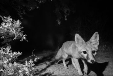
Kit Fox: CSDP Photographs Another First
By Jessica Moreno, Conservation Science Director It’s late morning in early May when my phone buzzes with a text message from my friend and long-time Desert Monitor Josh Skattum. It’s […]
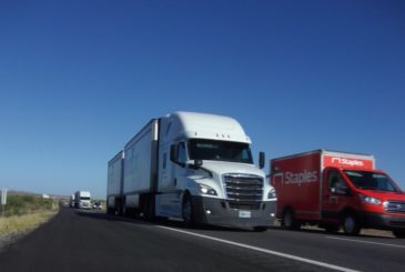
Reducing Roadkill: Safe Passages for Wildlife on Interstate-10 East
By Jessica Moreno, Conservation Science Director One of the best things about doing roadkill surveys is watching the sunrise. During the monsoons, the sun breaks across the eastern horizon and […]

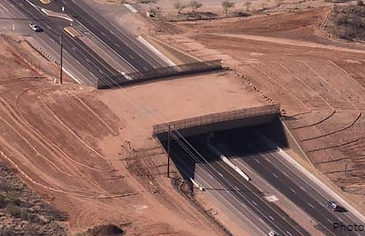
SR86 Wildlife Bridges move to siting and design phase
In January 2022, a group of people from Arizona Game and Fish Department, Arizona Department of Transportation, the Tohono O’odham Nation, and the Coalition for Sonoran Desert Protection conducted a […]

Crossing Through Your Neighborhood: A Presentation
Want to learn more about what’s happening around the Oracle Road wildlife crossings? Check out this recent presentation given by our Conservation Science Director Jessica Moreno: You can […]

Closing the Gap: Fencing gaps near the SR77 wildlife crossings are coming to a close
by Jessica Moreno, Conservation Science Director The last time I took a stroll down Big Wash, which runs along the west side of Oracle Road, the chill air pressed against […]

New data from the Tangerine Road wildlife underpasses
Did you know that there are five wildlife underpasses that traverse Tangerine Road? These wildlife underpasses were finished in 2018 and the Arizona Game and Fish Department (AGFD) is now […]
The latest monitoring data from the Oracle Road wildlife crossings!
Arizona Game and Fish Department (AGFD) just released the latest and greatest monitoring data from the Oracle Road wildlife overpass and underpass. This represents FOUR FULL YEARS of monitoring these […]

Oracle Road wildlife crossings featured on FOX10 Drone Zone segment
The Oracle Road wildlife crossings were recently featured on TV station FOX10’s Drone Zone segment in Phoenix. Check out this 3+ minute segment to see some amazing drone footage of […]

The latest numbers from our wildlife camera program
Thanks to all of our supporters and volunteers for another year of successful wildlife camera monitoring in the Tucson Mountains and Oro Valley study areas! See an overview of our […]
New video about Nevada wildlife crossings worth a watch
Our friends at Wildlands Network shared a new short film about wildlife crossings in Nevada – it’s well worth watching! From their email about the film: “ARC Solutions and the […]