Posts Tagged ‘conservation’
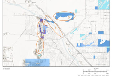
Tucson-Tortolita Mountains Wildlife Linkage: The Latest Data and Looking Ahead
Last month we shared that we expanded this project in 2022, with cameras on either side of I-10 between the Tucson Mountains and Tortolita Mountains, and six more planned to be placed in 2023. Here are some details on what we’ve found so far!
Our project is comparing five study areas, each with four cameras placed at least 200m apart. These areas are shown in the map below: Private lands in the northern Tucson Mountain range (1), Los Morteros & Rattlesnake Pass (2), El Rio Preserve (3), the Santa Cruz River (4), and Pima County Conservation lands east of Interstate 10 called Cascada (5). These study areas make up a large part of the Tucson-Tortolita Wildlife Linkage, and each has different topography, elevation, distance to water, and other unique habitat features.
Our results show that each study area is dominated by different species, but there are common species throughout, namely mule deer, coyote, bobcat, javelina, gray fox, and cottontail rabbit. Mountain lions have only been observed on Private lands, while kit fox and badger have only been photographed on Cascada lands. El Rio is thus far the least diverse in species (it is also the smallest area and the most impacted by people), while Private lands have been the most diverse – unless you count individual bird species, and then the Santa Cruz River area has them all beat. In addition to the exciting kit fox discovery, other notable species include hooded and spotted skunks, raccoon, and Mexican free-tailed bats.
Working with Pima County, this data is already informing a project to build a wildlife ramp from the only accessible wildlife crossings near Avra Valley Road, to provide entry into the Santa Cruz River over the water levy. We are also working on gaining permanent protection for the Tortolita Preserve and planning a large wildlife bridge over I-10, and a smaller crossing structure at Rattlesnake Pass. These crossings are being designed specifically with mule deer, mountain lion, and bighorn sheep in mind, but will benefit many species.
Thank you to all of our volunteers that are instrumental to this work and to our many member groups and community partners that are collaborating on this multi-pronged project!
The first Tortolita BioBlitz was a huge success!
On Saturday November 19th, 46 participants made almost 700 observations of over 135 species!
The first Tortolita Preserve BioBlitz was a huge success! What a great way to share and explore this amazing open space!
We held seven small group outings during the BioBlitz, and all the participants enjoyed getting a chance to explore with guides from Arizona Master Naturalists, Arizona Game and Fish Department, the Coalition for Sonoran Desert Protection, and Tortolita Alliance. One of the guided walks headed by CSDP’s Jessica Moreno focused on identifying animals by scat and tracks. Species identified included Grey Fox, Mule Deer, Bobcat, Coyote, and even the tiny and industrious Kangaroo Rat! Another walk conducted by Jennie McFarland from Tucson Audubon Society and Steven Prager from Audubon Southwest yielded a list of fifteen species including a Ruby-crowned Kinglet; the first time this species has been documented here on E-Bird. Another highlight was the identification of Gregg’s Nightblooming Cereus happily existing in the understory of a Palo Verde.
In addition to the outings, many people worked hard collecting observations on their own. We had several people visiting the Tortolita Preserve for the first time and others new to iNaturalist making a big contribution to the success of the event. Identifying observations made by others is another area in which our group really contributed. We had people making identifications during the BioBlitz. This is such an important part of the outreach component of iNaturalist, so a big thanks to people who worked on identifications!
Check out the project:
Tortolita Preserve Fall BioBlitz · iNaturalist

Jessica Moreno leads a dawn wildlife track and sign survey for the Tortolita Preserve BioBlitz to a group of BioBlitzers. Sunrise really lights up those tracks! It was a cold start, but warmed up quickly.
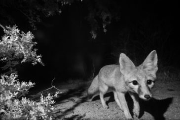
Kit Fox: CSDP Photographs Another First
By Jessica Moreno, Conservation Science Director
It’s late morning in early May when my phone buzzes with a text message from my friend and long-time Desert Monitor Josh Skattum. It’s a black and white photo from our “UTA” camera in the Tucson-Tortolita Mountain corridor, a blurry ghost of a fox with large, pointed ears and a small animal in its mouth, trotting swiftly through a moonless desert night. “Kit fox?,” Josh types. It looks plausible… I promise to look at it more closely and confirm.
The desert kit fox (Vulpes macrotis) has exaggerated features and could easily be included in a sci-fi wildlife field guide, fitting comfortably among the illustrations of banthas, sandworms, or tribbles. They are tiny canines, just 3.5 to 6 pounds, the weight of a full-grown Chihuahua. That small package comes with oversized 3- to 4-inch-long ears that helps dissipate the heat, a fluffy tail that nearly doubles its body length, and fur packed between their toes creating custom-made sand shoes.
Their soft sandy-colored coats are sometimes trimmed in bright rusty orange as if their edges were dyed by the desert sunset. In the moonlight, you might only glimpse pale fur and a black-tipped tail that doesn’t sport the signature bold black stripe found on the more commonly seen gray fox. But the kit fox’s delicate pointy face, bright eyes, and overlarge ears give them the same playful and mischievous countenance.
Several more nocturnal photos later, and I am more confident in my ID. Josh even documents a likely burrow site. Just to be doubly sure (and for fun), I ask for the help of Raynor Vandeven, a talented photographer who builds his own custom-made camera traps to produce incredible wildlife images. He sets out to see if he can get a more photographic image for us – with almost instant success.
These photos are the first time a kit fox has triggered one of the wildlife cameras we use to monitor the movement patterns of animals that use Pima County’s wildlife corridors. These areas tend to be the most threatened by roads and development – and also exactly the kind of low desert habitat that is preferred by kit foxes. And here they are, fulfilling their special role in the Sonoran Desert ecosystem as mesocarnivores.
A mesocarnivore is a small to mid-sized mammal that eats mostly meat (50 – 75% of their diet) but also eats other things – fruits, plants, fungi, insects – and is therefore an omnivore. Ecologically, they serve a role similar to the fewer-in-number large carnivores, like mountain lions, with some differences, such as spreading seeds that help plant dispersal, influencing disease dynamics, and being able to drive community structure (the types and number of species that live in a place and how they interact with one another). The disappearance of mesocarnivores on the landscape, both in abundance and diversity of species, is a canary in the mine for ecological health.
For their part, kit foxes primarily eat cottontail rabbits and rodents like kangaroo rats for their meat course. Very rarely they will eat the jackrabbits that complete with them for size. They will also eat carrion, birds, lizards, insects, quail eggs, saguaro fruit, prickly pear fruit, and mesquite beans. When food is plentiful, they might cache their meals by burying them, squirrel-like, and marking the spot with pee – a fox’s version of the office refrigerator lunchbox post-it note: My Lunch. Do Not Eat.
Kit foxes are solitary hunters and are often seen alone but are part of small family groups of parents and their young. Mates form a monogamous, permanent bond and both parents care for a single litter of 5 to 7 kits, or pups, that are born blind in March and April and remain in their cool den, with its keyhole-shaped entrance, until the monsoon arrives in June or July.
They can find food and mates, raise young, and disperse surprisingly long distances to new habitats – despite the challenges of mange caused by rodenticides, canine distemper and rabies, and the very pressing concerns of habitat loss, habitat fragmentation, and wildlife-vehicle collisions. Time will tell if rising temperatures and other threats prove too much, or are averted too late, for a species that has been with us since the Great Ice Age and survived the extinction of the larger Pleistocene megafauna.

Photo by Raynor Vandeven
Today these tiny, playful desert den dwellers are considered vulnerable in Arizona but do not have any protected status. Their distribution is extensive throughout the Great Basin, Sonoran, and Mojave deserts, but populations have generally been declining by 10-30% across their range, according to data collected on NatureServe. A fox to watch.
Our nocturnal kit foxes continue to bless the desert night with their yips, barks, and chuckles. Tonight, I allow myself to imagine that they sometimes gaze up at the stars, above the haze of nearby city lights and horizon of creosote, stars that for untold generations have been their only constant. The chuckle in the dark desert night I hear sounds like an echo of Josh’s laugh.

Kit fox habitat (in bright green), in eastern Pima County, along with two of our wildlife linkage study areas in the Tucson-Tortolita Mountains wildlife linkage and the Catalina-Tortolita Mountains wildlife linkage.
Pima County’s Open Space Conservation Acquisitions: An Overview
Pima County has invested heavily in acquiring conservation properties, especially in fulfilling the goals of the Sonoran Desert Conservation Plan. The County recently released a new report about all their open space conservation acquisitions. Along with providing a comprehensive overview of this decades-long program, the report specifically touches on the transparent public processes underlying the prioritization of eligible lands, funding mechanisms, and benefits these lands bring to the community.

This map from page 13 of the report shows the full suite of conservation lands in Pima County, including the open spaces owned or managed by Pima County in green and open spaces owned or managed by other jurisdictions (such as the Forest Service, National Park Service, etc.) in yellow.
You can check out the full report HERE.
Thank you for supporting our work as a partner and advocate for connected and robust protected open space in the Sonoran Desert!
Oracle Road wildlife crossings featured on FOX10 Drone Zone segment
The Oracle Road wildlife crossings were recently featured on TV station FOX10’s Drone Zone segment in Phoenix. Check out this 3+ minute segment to see some amazing drone footage of both the Oracle Road wildlife underpass and overpass, along with a great interview of our partner Jeff Gagnon with the Arizona Game and Fish Department (click on the image/link below to access the full TV segment).
The latest numbers from our wildlife camera program
Thanks to all of our supporters and volunteers for another year of successful wildlife camera monitoring in the Tucson Mountains and Oro Valley study areas! See an overview of our Tucson Mountain camera project results HERE and our Oro Valley camera project results HERE.
We have been monitoring wildlife with wildlife cameras in the northern portion of the Tucson Mountains and Avra Valley for four years. To date we’ve seen over 30 species across 23 camera sites, data which helps inform our I-11 work and knowledge about the Tucson-Tortolita Mountain Wildlife Linkage. Javelina have been photographed most frequently, and it is good to see these native seed dispersers out and about! Other notable results in the last year include more badgers, and bobcats with kittens in tow.
In Oro Valley, we have been monitoring east and west of the Oracle Road wildlife bridge and underpass for a total of seven years! We now have excellent comparative data pre- and post- construction of the crossings that were built in May 2016. With 62 species across 49 camera sites (and nearly 78,000 photos!), we are seeing lots of cottontails and quail that are plentiful prey for coyotes, bobcats, and gray foxes. We’ve seen white-nose coati and bighorn, and our resident female mountain lion has appeared again this year several times just west of the wildlife bridge.
We will post more detailed results as we finalize project reports and dive into the fun and useful information these cameras have in store!
Coalition staffer presents on I-10 Safe Passages Project at International Conference on Ecology and Transportation
By Myles Traphagen, Borderland Programs Coordinator, Wildlands Network
Sacramento, California was the location of the tenth biennial International Conference on Ecology and Transportation (ICOET) held September 22 to 26th, 2019. Jessica Moreno, the Coalition for Sonoran Desert Protection’s Conservation Science Director, presented the “Safe Passages for Wildlife on Interstate-10 within the Rincon-Santa Rita-Whetstone Mountains Wildlife Linkage” project, made possible by a generous grant from the Arizona Game and Fish Department Heritage Fund.
Nearly 600 delegates from 19 countries attended the four-day conference held at the Hyatt Regency directly across the street from the California State Capitol building. The vast array of topics at the conference ranged from camera trapping workshops, wildlife crossing structure design, public policy, and the state of transportation ecology around the globe.
With nearly 4 million miles of roads in the United States, and the ever-increasing paving of new roads globally (estimated to total 16 million miles by 2050), the effects of mechanized human transport on wildlife, biodiversity, and highway safety are staggering. The constant, daily stress exerted upon wildlife and biodiversity by roads cannot be ignored. The Coalition for Sonoran Desert Protection is actively addressing this issue through a variety of projects, and the Safe Passages presentation made by Jessica at the ICOET Conference was the final presentation in the Connecting Plans to Action session, for action is our modus operandi.
The 20-mile stretch of Interstate 10 between the Highway 83 and first Benson exit is the focus of our project. It’s obvious to anybody who has driven through this stretch that the numerous drainages and arroyos, like Davidson Canyon and Cienega Creek (which encompass several protected areas and important waters in the eastern Sonoran Desert), provide a natural travel corridor for animals that migrate between the Sky Island mountains north and south of I-10. This area has been a frequent zone of wildlife vehicle collisions. It’s no accident that these unfortunate “accidents” occur, because the Arizona Wildlife Linkages Assessment identified several wildlife corridors that cross right through here. This underscores the perils of the linear infrastructure like roads, railways, power lines and canals that increasingly dominate our modern world.
Now in Phase II, the I-10 Safe Passages project is using wildlife camera monitoring and roadkill surveys, along with community science engagement, to gather species-specific baseline data on wildlife passage rates and roadkill hotspots. We couldn’t do this important work without our dedicated volunteer team of “Desert Roadies” to help us with the driving surveys. Preliminary results, including a black bear mortality on August 23rd at mile marker 289 at Cienega Creek, have already begun to identify optimum locations for wildlife funnel-fencing installation, existing culvert retrofits, and new wildlife crossing structures. These data will inform State and County highway and wildlife officials on where to focus mitigation efforts to improve highway safety and minimize wildlife-vehicle collisions, and to provide justification for project funding.
In the US alone, it is estimated that there are between one and two million large animal wildlife vehicle collisions a year with hundreds of human fatalities as a result. The science of Road Ecology is attempting to reduce these occurrences by using crash analysis and GIS modeling of landscape variables that naturally funnel animals towards point specific places in their daily and seasonal movements. Progress is being made in identifying these places (like along I-10) where the greatest likelihood of wildlife collisions is predicted to occur.
With the data collected from the I-10 Safe Passages Project, we can identify and quantify wildlife vehicle collision hotspots and plan for and modify build-out plans to mitigate and respond accordingly to reduce these conflicts. In the case of the proposed Interstate 11, we support using avoidance and not building it in the first place! In the age of “Super-Commuters,” a term which the Director of the California Department of Fish and Wildlife used to describe drivers who spend two hours each way traveling to and from work, we need to rethink our approach to highway construction and proactively mitigate for and modify the design and building of roads. To learn more about how you can help by volunteering or donating, visit us here. Keep an eye out for wildlife and drive slower, safer and less when you can.

CSDP Conservation Science Director Jessica Moreno and Myles Traphagen, Borderlands Program Coordinator with Coalition member group Wildlands Network, at the International Conference on Ecology and Transportation in Sacramento, CA in September 2019.

CSDP Conservation Science Director Jessica Moreno presents on the Coalition’s new I-10 Safe Passages project, funded by the Arizona Game and Fish Department Heritage Fund.
New report on I-11 calls it a “white elephant” and “unnecessary”
On August 8, 2019, the Center for American Progress released a new report on the proposed Interstate 11 as part of its “White Elephant Watch” series, which “profiles projects that demonstrates the failures of the current U.S. policy approach to transportation infrastructure.”
This report provides a detailed analysis of this proposed project, including a point-by-point analysis of the Purpose and Need section of the Draft Environmental Impact Statement. The report concludes the following:
“ADOT’s proposed I-11 corridor has four major flaws:
- Fails to increase transportation choice or reduce local single-occupant vehicle trips made within the Phoenix and Tucson metro areas
- Promotes low-density land use and dependence on automobility
- Produces significant environmental harms
- Is based on flawed travel demand models that do not adequately account for induced demand”
The report can be found online and as a pdf document. It is well worth a few minutes of your time to read this timely and well-written report!
Pima County releases Aquatic Species Management Plan
In July 2019, as part of the continued implementation of their Multi-Species Habitat Conservation Plan (MSCP), Pima County released a new Aquatic Species Management Plan. According to Pima County Environmental Planning Manager, Julia Fonseca:
“The Plan identifies opportunities for releasing target species on County-managed conservation lands where they do not currently occur.
The Plan inventoried streams, springs, stock tanks and large ponds for opportunities for releasing target species where they do not currently occur. Species with the most release opportunities are the Gila topminnow (15 sites) and Huachuca water umbel (14 sites). The most widespread target species on County conservation lands is the lowland leopard frog; there are eight additional sites available for future releases of this species. Opportunities at small, confined sites also exist, like the recent release of topminnow and umbel species at Mission Garden.
The Plan is a required element of the Multi-species Conservation Plan (MSCP). It supports implementation of Arizona Game and Fish Department’s (AZGFD’s) priorities for the Santa Cruz watershed, as well as recovery objectives established by U. S. Fish and Wildlife Service (USFWS). The Plan does not direct, authorize or fund any particular action on land owned or managed by Pima County or the Regional Flood Control District. Implementation will depend on partnerships with AZGFD and other conservation partners over the 30-year term of the MSCP.
The Plan includes guidelines prepared by USFWS for construction of wildlife-friendly water features. These guidelines may be of interest to private property owners who wish to maximize benefits and minimize risks to Arizona’s wildlife.”
We commend Pima County for their continued implementation of the MSCP since it was approved by the USFWS in 2016. And thank you for supporting the conservation of our must vulnerable Sonoran Desert wildlife species through our work advocating for the MSCP since 2000.
You can learn more about the MSCP at our Habitat Conservation Planning webpage.
The latest and greatest monitoring results from the Oracle Road wildlife crossings
In March 2019, the Arizona Game and Fish Department (AGFD) released their latest monitoring results from the Oracle Road wildlife crossings. AGFD typically releases monitoring results twice a year so we should have an updated monitoring report sometime this fall.
March 2019 AGFD Monitoring Report on the Oracle Road wildlife crossings
Two summary graphs from the report are highlighted below:

This graph shows the total mule deer crossings at both the Oracle Road underpass and bridge. Mule deer started using the bridge almost immediately after construction finished and have been used it steadily ever since (blue line). More recently, mule deer have become more acclimated to using the underpass, with increasing numbers successfully crossing all the way through the underpass since Winter 2018. It is well established that some wildlife species will use wildlife crossings right away with little acclimation while others may take years before they become acclimated and then will start using the crossing regularly.

This graph shows the total crossings by all wildlife species at both the Oracle Road underpass and bridge. Wildlife started using both crossings very soon after construction completed and have been using them steadily ever since. This new connectivity across Oracle Road increases the health of our local wildlife populations by allowing them to reach new home ranges and find mates (which then supports healthy genetic diversity) and also increases the safety of Oracle Road itself with a reduction in wildlife-vehicle collisions. Miles of wildlife fencing was also installed as part of this project – the fencing directs wildlife to the crossings themselves and was designed using the best available science to accommodate a wide range of wildlife species.
Want to learn more about the Oracle Road wildlife crossings, why they are located where they are, how wildlife know to use them, how they were funded, and much more? Our website includes:
- An Overview of the Oracle Road wildlife crossings,
- A long list of Frequently Asked Questions,
- A look at The Big Picture, including existing plans to make sure land on both sides of the crossings stays protected as open space,
- A summary of Monitoring Results (which we will be updating soon!)