Your gift today will protect open spaces, wildlife, and wildlife linkages. Donate Now

Posts Tagged ‘camera volunteers’

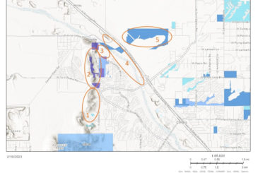
Tucson-Tortolita Mountains Wildlife Linkage: The Latest Data and Looking Ahead

Posted on:

Last month we shared that we expanded this project in 2022, with cameras on either side of I-10 between the Tucson Mountains and Tortolita Mountains, and six more planned to be placed in 2023. Here are some details on what we’ve found so far!

Our project is comparing five study areas, each with four cameras placed at least 200m apart. These areas are shown in the map below: Private lands in the northern Tucson Mountain range (1), Los Morteros & Rattlesnake Pass (2), El Rio Preserve (3), the Santa Cruz River (4), and Pima County Conservation lands east of Interstate 10 called Cascada (5). These study areas make up a large part of the Tucson-Tortolita Wildlife Linkage, and each has different topography, elevation, distance to water, and other unique habitat features.


Our results show that each study area is dominated by different species, but there are common species throughout, namely mule deer, coyote, bobcat, javelina, gray fox, and cottontail rabbit. Mountain lions have only been observed on Private lands, while kit fox and badger have only been photographed on Cascada lands. El Rio is thus far the least diverse in species (it is also the smallest area and the most impacted by people), while Private lands have been the most diverse – unless you count individual bird species, and then the Santa Cruz River area has them all beat. In addition to the exciting kit fox discovery, other notable species include hooded and spotted skunks, raccoon, and Mexican free-tailed bats.

Working with Pima County, this data is already informing a project to build a wildlife ramp from the only accessible wildlife crossings near Avra Valley Road, to provide entry into the Santa Cruz River over the water levy. We are also working on gaining permanent protection for the Tortolita Preserve and planning a large wildlife bridge over I-10, and a smaller crossing structure at Rattlesnake Pass. These crossings are being designed specifically with mule deer, mountain lion, and bighorn sheep in mind, but will benefit many species.

Thank you to all of our volunteers that are instrumental to this work and to our many member groups and community partners that are collaborating on this multi-pronged project! 

2022 Wildlife Camera Project Recap

Posted on:

2022 was another successful year for our Wildlife Camera Monitoring Program, and also our 10th anniversary of this community science-based project! Big thanks to ALL the volunteers that have been the engine behind this project from day one! 


Oro Valley Linkage Wildlife Monitoring

This is the project that started it all, and gives us the distinction of having the oldest and longest lasting community science wildlife camera monitoring effort in southern Arizona. Today we have 24 active cameras on either side of Oracle Road, that have gathered over 300,000 images of wildlife, including a mountain lion who moved through the underpass this year. We have also identified 24 wildlife species in this area, with the addition of a black bear this past year. 

Watch a presentation about this project here.

This happy coyote was photographed near the Oracle Road wildlife underpass by our CONFORTI camera, monitored by Pat & Henry Miller.


Tucson Mountains Linkage Wildlife Monitoring

We have expanded this project this year, with 24 cameras on either side of I-10 between the Tucson Mountains and Tortolita Mountains, and 6 more planned to be placed in 2023. These cameras have captured nearly 124,000 wildlife photos over the life of the project! We have also identified 26 different wildlife species in this area, with the addition of the kit fox this past year.

Working with Pima County, this data is already informing a project to build a wildlife ramp from the only accessible wildlife crossings near Avra Valley Road, to provide entry into the Santa Cruz River over the water levy. We are also working on gaining permanent protection for the Tortolita Preserve, and planning a wildlife bridge over I-10 and another at Rattlesnake Pass.

Two coyote pups in the Tucson Mountains. Photo by Raynor Vandeven.


Sopori Ranch Linkage Wildlife Monitoring

In partnership with the Arizona Land and Water Trust, we are monitoring this linkage and using the images to promote this wild corridor. Today we have 5 cameras that have produced nearly 4,000 images and growing.

Watch a video showcasing this area here.

A deer navigating a wash in the Sopori Creek area.


I-10 East Linkage Wildlife Monitoring

The I-10 East project involved two seasons of roadkill surveys and two years of monitoring key culverts and bridges for wildlife use and passage rates. Exactly 45 wildlife cameras were active between January 2020 and January 2022, during which time we collected over 789,000 photos and have identified over 36 species across our 10 monitoring sites, including both mule deer and white-tail deer, Mexican opossum, black bear, mountain lion, Gould’s turkey, white-nose coati, ringtail, striped skunk, hognose skunk, hooded skunk, Western spotted skunk, and badger.

Interesting records included a photo of a bobcat carrying a bull snake in its mouth, the Mexican opossum, and images of a likely mating pair of adult mountain lions traveling together.

 This data report is being incorporated into a proposal for wildlife funnel fencing and improved underpass and bridge structures for wildlife. Pima County is also using this data to justify a funding grant to make surface water improvements near these sites, and we collaborated to submit scoping comments in October 2022 for an upcoming ADOT project to help improve the area with highest roadkill mortality in our roadkill study between mileposts 292-294.

Read the Final Report here.

A deer heads towards a wildlife underpass in the I-10 East area with the lights of cars seen above. Photo by Raynor VanDeven.


SnapShot USA in full swing

Posted on:

The Snapshot USA project is a huge collaborative effort to sample mammal populations with camera traps across all of the United States. The study is designed to sample sites in all 50 states stratified across habitats and development zones (suburban/rural/wild/urban) with an objective of at least 400 “trap nights” (or days) per sub-project/ organization. 

This year we were able to contribute camera data from 12 cameras in our Oro Valley study area, for the study period of September and October.

Despite a few challenges with vegetation growth creating lots of blank images, we contributed 3,208 photos of species including javelina, jackrabbits, coyotes, bobcats, mule deer, white-tail deer… and even a surprise black bear on the MALLOW camera! The entire effort has collected photos of 384 species at over 2,000 camera sites across the U.S.

As science papers come out of this data, we will share the results and findings with you, and we look forward to contributing again next year!

Twelve wildlife camera images in a grid with the animals circled in a red, taken from a screenshot of website.

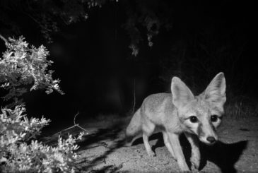
Kit Fox: CSDP Photographs Another First

Posted on:

By Jessica Moreno, Conservation Science Director

It’s late morning in early May when my phone buzzes with a text message from my friend and long-time Desert Monitor Josh Skattum. It’s a black and white photo from our “UTA” camera in the Tucson-Tortolita Mountain corridor, a blurry ghost of a fox with large, pointed ears and a small animal in its mouth, trotting swiftly through a moonless desert night. “Kit fox?,” Josh types. It looks plausible… I promise to look at it more closely and confirm.

The desert kit fox (Vulpes macrotis) has exaggerated features and could easily be included in a sci-fi wildlife field guide, fitting comfortably among the illustrations of banthas, sandworms, or tribbles. They are tiny canines, just 3.5 to 6 pounds, the weight of a full-grown Chihuahua. That small package comes with oversized 3- to 4-inch-long ears that helps dissipate the heat, a fluffy tail that nearly doubles its body length, and fur packed between their toes creating custom-made sand shoes.

Their soft sandy-colored coats are sometimes trimmed in bright rusty orange as if their edges were dyed by the desert sunset. In the moonlight, you might only glimpse pale fur and a black-tipped tail that doesn’t sport the signature bold black stripe found on the more commonly seen gray fox. But the kit fox’s delicate pointy face, bright eyes, and overlarge ears give them the same playful and mischievous countenance.

Several more nocturnal photos later, and I am more confident in my ID. Josh even documents a likely burrow site. Just to be doubly sure (and for fun), I ask for the help of Raynor Vandeven, a talented photographer who builds his own custom-made camera traps to produce incredible wildlife images. He sets out to see if he can get a more photographic image for us – with almost instant success.

These photos are the first time a kit fox has triggered one of the wildlife cameras we use to monitor the movement patterns of animals that use Pima County’s wildlife corridors. These areas tend to be the most threatened by roads and development – and also exactly the kind of low desert habitat that is preferred by kit foxes. And here they are, fulfilling their special role in the Sonoran Desert ecosystem as mesocarnivores.

A mesocarnivore is a small to mid-sized mammal that eats mostly meat (50 – 75% of their diet) but also eats other things – fruits, plants, fungi, insects – and is therefore an omnivore. Ecologically, they serve a role similar to the fewer-in-number large carnivores, like mountain lions, with some differences, such as spreading seeds that help plant dispersal, influencing disease dynamics, and being able to drive community structure (the types and number of species that live in a place and how they interact with one another). The disappearance of mesocarnivores on the landscape, both in abundance and diversity of species, is a canary in the mine for ecological health.

For their part, kit foxes primarily eat cottontail rabbits and rodents like kangaroo rats for their meat course. Very rarely they will eat the jackrabbits that complete with them for size. They will also eat carrion, birds, lizards, insects, quail eggs, saguaro fruit, prickly pear fruit, and mesquite beans. When food is plentiful, they might cache their meals by burying them, squirrel-like, and marking the spot with pee – a fox’s version of the office refrigerator lunchbox post-it note: My Lunch. Do Not Eat.

Kit foxes are solitary hunters and are often seen alone but are part of small family groups of parents and their young. Mates form a monogamous, permanent bond and both parents care for a single litter of 5 to 7 kits, or pups, that are born blind in March and April and remain in their cool den, with its keyhole-shaped entrance, until the monsoon arrives in June or July.

They can find food and mates, raise young, and disperse surprisingly long distances to new habitats – despite the challenges of mange caused by rodenticides, canine distemper and rabies, and the very pressing concerns of habitat loss, habitat fragmentation, and wildlife-vehicle collisions. Time will tell if rising temperatures and other threats prove too much, or are averted too late, for a species that has been with us since the Great Ice Age and survived the extinction of the larger Pleistocene megafauna.

Photo by Raynor Vandeven


Today these tiny, playful desert den dwellers are considered vulnerable in Arizona but do not have any protected status. Their distribution is extensive throughout the Great Basin, Sonoran, and Mojave deserts, but populations have generally been declining by 10-30% across their range, according to data collected on NatureServe. A fox to watch. 

Our nocturnal kit foxes continue to bless the desert night with their yips, barks, and chuckles. Tonight, I allow myself to imagine that they sometimes gaze up at the stars, above the haze of nearby city lights and horizon of creosote, stars that for untold generations have been their only constant. The chuckle in the dark desert night I hear sounds like an echo of Josh’s laugh.


Kit fox habitat (in bright green), in eastern Pima County, along with two of our wildlife linkage study areas in the Tucson-Tortolita Mountains wildlife linkage and the Catalina-Tortolita Mountains wildlife linkage.

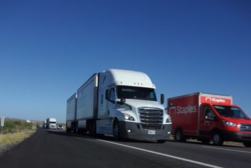
Reducing Roadkill: Safe Passages for Wildlife on Interstate-10 East

Posted on:

By Jessica Moreno, Conservation Science Director

One of the best things about doing roadkill surveys is watching the sunrise. During the monsoons, the sun breaks across the eastern horizon and lights up the moisture laden air and morning cloud cover with light and throws the foothills into brilliant color. The sun feels hopeful and the day new. The second-best thing is knowing that every datapoint is helping us make things better.

The 20-mile stretch of Interstate-10 (I-10) between Vail and Benson, east of Tucson, Arizona, divides the regionally important Rincon-Santa Rita-Whetstone Mountains Wildlife Linkage. This wildlife pathway is one of only a few – somewhat safe – crossing points across I-10 found between Tucson and New Mexico, and it encompasses several protected areas and important waters, including Davidson Canyon and Cienega Creek, making it critically important for desert wildlife in the face of climate change.


Thanks to aerial support provided by LightHawk, in February 2020 we were able to take to the air and photograph the project study area. The above photo is a view of the Rincon Mountains to the north with Cienega Creek and I-10 in the foreground. The Cienega Creek bridge, on the far center right, is one of the project’s wildlife camera monitoring sites, and cameras have been placed at each of the tributary drainages where they cross I-10. Roadkill surveys stretched from SR 83 to SR 90. Photo by Jessica Moreno, CSDP.


This wildlife pathway is protected partially by federally protected lands including Saguaro National Park, Rincon Wilderness, and Las Cienegas National Conservation Area. Pima County has invested in securing additional conservation lands in this linkage as mitigation under the Multi-Species Conservation Plan (MSCP), including Bar V Ranch, Cienega Creek Natural Preserve, Rancho Agua Verde, and Colossal Cave Mountain Park, which are managed under the Cienega Creek Management Plan.

However, I-10 cuts through this area of wildlife movement, resulting in more wildlife-vehicle collisions for large animals such as black bear, mule deer, whitetail deer, javelina, coyote, and mountain lion, as well as smaller species like box turtles, opossum, Antelope jackrabbit, white-nose coati, raccoon, badger, and bobcat. It also serves as a potential movement area for jaguars and ocelots. Existing culverts and right of way fencing are not currently adequate at reducing wildlife-vehicle collisions or ensuring safe wildlife passage in this area. Future growth and increases in traffic volumes will only worsen the frequency of vehicle-wildlife collisions.

Since 2006, several qualitative assessments and reports have been produced that highlight the area’s importance for wildlife movement, but there has not been a study that has collected data to build a high accuracy model of wildlife movements and roadkill locations along this corridor. With the lack of such a product, nothing has been done on the ground to reduce wildlife-vehicle collisions and to improve safe wildlife passage by employing effective mitigation structures like winged highway fencing or wildlife overpasses. The Coalition for Sonoran Desert Protection, in conjunction with partners, is spearheading the effort to collect data to provide the information necessary to make this stretch of I-10 a safer passage for both wildlife and people in this important corridor.


Raynor VanDeven captured this photo of a mule deer near one of our culvert study sites under I-10, just east of Davidson Canyon, with bright tail lights on the highway above appearing to streak across the night sky. He uses a custom built wildlife camera trap to gather these professional photos. Raynor’s work has been a tremendous contribution to this project!


In the spring of 2017, CSDP conducted comprehensive assessments and wildlife surveys of the nearly 80 existing concrete box culverts and metal plate pipe structures between milepost 277-302 (Houghton Road to SR90), with participants from several government, nonprofit, and community partners, including the Arizona Game and Fish Department, Cochise County, Pima County, Tucson Audubon Society, Sky Island Alliance, Defenders of Wildlife, and the Wildlands Network. Our results indicated that this wildlife linkage could be made safer for wildlife and motorists by 1) installing wildlife funnel-fencing to keep animals off the highway and to direct wildlife toward existing crossing points; 2) retrofitting and widening existing drainage culverts located in high volume areas; and 3) construction of an additional wildlife crossing between Cienega Creek and the railroad underpass near Empirita Rd Exit 292.

Roadkill surveys were part of the next phase of this effort: to gather data on roadkill hotspots, together with wildlife passage rates using wildlife cameras in the best existing culverts. We hope this data will inform State and County highway and wildlife officials on where to focus mitigation efforts to improve highway safety and minimize wildlife-vehicle collisions with site-specific wildlife funnel-fencing installation, existing culvert retrofits, and new wildlife crossing structures. Our results illustrate the need to implement changes and provides baseline information to evaluate the success of future mitigation measures.

Our Desert Roadies project began with a team of volunteers to help collect wildlife-vehicle mortality data on Interstate-10 between SR83 and SR90, east of Tucson. Desert Roadies volunteers worked in teams of 2-4 people, including myself, to conduct driving roadkill surveys. Observations were recorded by our notetaker with the GPS coordinates. Surveys were conducted in the morning, starting up to 30 minutes before sunrise, every week for 6 weeks during the monsoon season in 2019 and 2020, beginning in July, except when conditions were bad for visibility or driving such as rain, dust storms, or other low visibility weather. In addition to these formal roadkill surveys, we collected other data on iNaturalist.org from community members and personally investigated reports about black bear mortalities. We also requested ADOT records on reported animal-vehicle crashes in the study area. This data was analyzed separately.  

Due to the onset of the Covid-19 pandemic in March 2020, carpooling with volunteers was no longer a safe option. So, we adapted as best we could by canceling the planned spring 2020 survey and having another monsoon season survey instead, which was conducted by myself and my family, Eddie Moreno (who is also a biologist experienced in roadkill surveys) and my two toddlers munching on donuts and “helping” look for animals from the backseat. This survey was done when the state was under curfew and lockdown, resulting in reduced traffic volumes. This likely was one reason for fewer observations of roadkill during this survey window.

Walking surveys are the ideal method for complete and accurate data. But safety concerns eliminated that option because we are using volunteer participation and this is a busy interstate highway with narrow right of ways. Therefore, the roadkill survey portion of this project was designed to be a broad-brush stroke only and we anticipated a small sample size. Recording categories of small, medium, large animals and/or by clade (reptile, bird, small/med/large mammal) are adequate for our purpose. Because of the project design, we have near zero detectability of small animals, and instead our target species are deer, bear, coyote, bobcat, gray fox, javelina, and those larger animals that the Arizona Department of Transportation consider most hazardous to drivers. The data will hopefully serve to provide a preliminary look at potential roadkill hotspot areas. For best accuracy 1) our GPS units had a one-button click to mark points quickly, 2) volunteers could also use maps and mileposts to confirm locations, 3) we analyzed the data in 1-mile segments, which better informs the fencing solution strategy and somewhat addresses imprecise location information, and 4) a staff biologist was always present to provide corroborating identification.

We completed two monsoon survey seasons for roadkill observations in 2019 and 2020, resulting in 78 data points of at least 14 different species. We were able to detect animals as small as a rock squirrel or cottontail rabbit. Skunks, raptors, and deer were not identified to specific species. All of our deer mortality observations (n=2) occurred between mileposts 296-297, near the Pima-Cochise County line. A hotspot of roadkill observations occurred between mileposts 291-295 (between Cienega Creek and Empirita Rd), in an area that coincides with a gap in available culverts and crossing points, and near several culvert locations between mileposts 283-287.

Coyotes, cottontail rabbits, and javelina were the most abundant roadkill species observed during our surveys. We also observed skunks, badger, opossum, raccoons, mule deer, jackrabbits, gray fox, domestic dogs, and raptors. Our 2020 monsoon survey occurred during a state lockdown at the beginning of the Covid-19 pandemic, and less traffic may be one reason for the reduction of roadkill during this survey period. Bruce Jacobsen created this “heat” map showing hotspots of our observations.


Our roadkill survey results for 2019 and 2020 monsoon survey seasons show hotspots around culverts east of Davidson Canyon, including an eastbound lane culvert that opens up to the median without a way across the westbound lane at milepost 285. Another larger hotspot appears between Cienega Creek and Empirita Road, which coincides with an area absent of available culverts for wildlife to use as crossing points.


The Arizona Department of Transportation (ADOT) collects crash records from police reports of vehicle crashes. Vehicle crashes caused by “animals” in recent years align with where we are seeing larger animals (deer, black bear) being hit most frequently on the interstate. Crash records can help make the case for increasing human safety by improving safe passage for wildlife – in addition to the goal of protecting healthy wildlife populations.


I-10 has been identified as a significant barrier to black bears in southern Arizona. In 2011, Todd Atwood et al published a study describing I-10 as a more significant barrier to functional gene flow for black bears than the U.S.-Mexico border, identifying I-10 as the dividing line between the Border subpopulation of black bears to the south, and the White Mountain subpopulation to the north. In our study area, these subpopulations meet and Romeo and Juliet romances unfold, ensuring healthy black bear populations in Arizona and in Mexico. For black bears, I-10 may be a barrier to gene flow as well as a “population sink” due to wildlife-vehicle deaths. This could pose a significant issue for the Border subpopulation, which additionally faces barriers to movement at the U.S.-Mexico border due to the construction of the border wall and other border-related infrastructure such as roads and lighting. Without safe passage both north of I-10 or south of the border, our southern Arizona black bears are at risk of genetic isolation and disappearing all together (what we call extirpation).

We have gathered four records of black bear mortalities in recent years, and three of these are verified with photos. These records indicate that the bears attempted to cross I-10 by following higher elevation ridgelines closely associated with the two largest underpass structures at Davidson Canyon and Cienega Creek. We also have animal track and camera trap data showing successful passage under I-10 at a few specific culverts. Most of our observations show bears moving south. April-May and August-September appear to be peak periods of activity for black bears in this area according to our data.

Black bears are just one example of the impact I-10 is having on native wildlife. In addition to large animals like bear, deer, and jaguar, smaller animals are at risk as well. Saguaro National Park has been monitoring a disturbing decline in “lost carnivores” over the last decade, including skunks, foxes, and badgers. Biologists are also concerned about the local disappearance of smaller range habitat specialist species affected by habitat fragmentation, including box turtles, Antelope jackrabbits, skunks, kit foxes, badgers, and white-nose coati. Increasing wildlife connectivity conditions for black bears and deer should allow struggling populations to repopulate from connected habitat areas and also benefit a wide array of other species.

In addition to our roadkill survey data, we were also able to collect four records of black bears killed by vehicle collisions in our study area. Bear roadkill occurred near mileposts 285 and 289-290, associated with the higher ridge lines close to Davidson Canyon and Cienega Creek. Deer collisions, on the other hand, were largely occurring near mileposts 296-297, where the landscape is naturally flatter.


With the data we’ve collected, we have solid evidence to back up the need for funding wildlife funnel fencing where it is most needed and make the case for new or improved wildlife crossings.


Read CSDP’s final project report to Arizona Game and Fish Department here.
(Please note: Photos of roadkill animals are included in the report)


Want to help?

Although collecting information on roadkill is not for the faint of heart, the data it provides is valuable. In the future, CSDP will be looking to continue our Desert Roadies program in more areas. In the meantime, folks can also document sightings of wildlife on roads in Pima County at https://www.inaturalist.org/projects/csdp-safe-passages.


Interstate 10 is a busy roadway, with 4 divided lanes and frequent commercial truck traffic. Adding wildlife funnel fencing to existing crossing structures is one simple solution to improve safe wildlife passages in this linkage. Photo by Matt Clark.


Acknowledgements

This work was made possible thanks to the time, effort, and skill of the following volunteers: Matt Clark, Sami Hammer, Bruce Jacobsen, Ken Lamberton, Eduardo Moreno, D’angelo Padilla, Raynor VanDeven, Althea Weeks, and Daisy Weeks.

We also want to thank Scott Sprague, Jeff Gagnon and Brit Oleson of the Arizona Game and Fish Department, and give special thanks to our collaborating partners: Myles Traphagen with The Wildlands Network and Brian Powell with Pima County Natural Resources, Parks and Recreation.

This project was funded in part by the Arizona Game and Fish Department Heritage Fund.


Crossing Through Your Neighborhood: A Presentation

Posted on:

Want to learn more about what’s happening around the Oracle Road wildlife crossings? Check out this recent presentation given by our Conservation Science Director Jessica Moreno:


You can also view a pdf of the presentation HERE

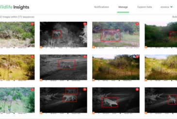
New wildlife cameras generate spectacular photos

Posted on:

Thanks to a new partnership with volunteer, welder, and ecology student Raynor Vandeven, there are now four wildlife cameras out in the field with professional photography equipment capturing images of Sonoran Desert wildlife. These cameras are located in an area along the proposed I-11 route, in the Tucson Mountains, near the Oracle Road wildlife crossings, and in the I-10 East wildlife linkage area. 

We are so grateful to Raynor for his willingness to share these images with the Coalition and can’t wait to start sharing more of them with you in the weeks and months ahead! 

(Note: the photos below are examples of Raynor’s wildlife photography and were not taken in the locations described above. )


The latest numbers from our wildlife camera program

Posted on:

Thanks to all of our supporters and volunteers for another year of successful wildlife camera monitoring in the Tucson Mountains and Oro Valley study areas! See an overview of our Tucson Mountain camera project results HERE and our Oro Valley camera project results HERE.


We have been monitoring wildlife with wildlife cameras in the northern portion of the Tucson Mountains and Avra Valley for four years. To date we’ve seen over 30 species across 23 camera sites, data which helps inform our I-11 work and knowledge about the Tucson-Tortolita Mountain Wildlife Linkage. Javelina have been photographed most frequently, and it is good to see these native seed dispersers out and about! Other notable results in the last year include more badgers, and bobcats with kittens in tow.

In Oro Valley, we have been monitoring east and west of the Oracle Road wildlife bridge and underpass for a total of seven years! We now have excellent comparative data pre- and post- construction of the crossings that were built in May 2016. With 62 species across 49 camera sites (and nearly 78,000 photos!), we are seeing lots of cottontails and quail that are plentiful prey for coyotes, bobcats, and gray foxes. We’ve seen white-nose coati and bighorn, and our resident female mountain lion has appeared again this year several times just west of the wildlife bridge.

We will post more detailed results as we finalize project reports and dive into the fun and useful information these cameras have in store!

Coalition staffer presents on I-10 Safe Passages Project at International Conference on Ecology and Transportation

Posted on:

By Myles Traphagen, Borderland Programs Coordinator, Wildlands Network

Sacramento, California was the location of the tenth biennial International Conference on Ecology and Transportation (ICOET) held September 22 to 26th, 2019. Jessica Moreno, the Coalition for Sonoran Desert Protection’s Conservation Science Director, presented the “Safe Passages for Wildlife on Interstate-10 within the Rincon-Santa Rita-Whetstone Mountains Wildlife Linkage” project, made possible by a generous grant from the Arizona Game and Fish Department Heritage Fund.

Nearly 600 delegates from 19 countries attended the four-day conference held at the Hyatt Regency directly across the street from the California State Capitol building. The vast array of topics at the conference ranged from camera trapping workshops, wildlife crossing structure design, public policy, and the state of transportation ecology around the globe.

With nearly 4 million miles of roads in the United States, and the ever-increasing paving of new roads globally (estimated to total 16 million miles by 2050), the effects of mechanized human transport on wildlife, biodiversity, and highway safety are staggering. The constant, daily stress exerted upon wildlife and biodiversity by roads cannot be ignored. The Coalition for Sonoran Desert Protection is actively addressing this issue through a variety of projects, and the Safe Passages presentation made by Jessica at the ICOET Conference was the final presentation in the Connecting Plans to Action session, for action is our modus operandi.

The 20-mile stretch of Interstate 10 between the Highway 83 and first Benson exit is the focus of our project. It’s obvious to anybody who has driven through this stretch that the numerous drainages and arroyos, like Davidson Canyon and Cienega Creek (which encompass several protected areas and important waters in the eastern Sonoran Desert), provide a natural travel corridor for animals that migrate between the Sky Island mountains north and south of I-10. This area has been a frequent zone of wildlife vehicle collisions. It’s no accident that these unfortunate “accidents” occur, because the Arizona Wildlife Linkages Assessment identified several wildlife corridors that cross right through here. This underscores the perils of the linear infrastructure like roads, railways, power lines and canals that increasingly dominate our modern world.

Now in Phase II, the I-10 Safe Passages project is using wildlife camera monitoring and roadkill surveys, along with community science engagement, to gather species-specific baseline data on wildlife passage rates and roadkill hotspots. We couldn’t do this important work without our dedicated volunteer team of “Desert Roadies” to help us with the driving surveys. Preliminary results, including a black bear mortality on August 23rd at mile marker 289 at Cienega Creek, have already begun to identify optimum locations for wildlife funnel-fencing installation, existing culvert retrofits, and new wildlife crossing structures. These data will inform State and County highway and wildlife officials on where to focus mitigation efforts to improve highway safety and minimize wildlife-vehicle collisions, and to provide justification for project funding.

In the US alone, it is estimated that there are between one and two million large animal wildlife vehicle collisions a year with hundreds of human fatalities as a result. The science of Road Ecology is attempting to reduce these occurrences by using crash analysis and GIS modeling of landscape variables that naturally funnel animals towards point specific places in their daily and seasonal movements. Progress is being made in identifying these places (like along I-10) where the greatest likelihood of wildlife collisions is predicted to occur.

With the data collected from the I-10 Safe Passages Project, we can identify and quantify wildlife vehicle collision hotspots and plan for and modify build-out plans to mitigate and respond accordingly to reduce these conflicts. In the case of the proposed Interstate 11, we support using avoidance and not building it in the first place! In the age of “Super-Commuters,” a term which the Director of the California Department of Fish and Wildlife used to describe drivers who spend two hours each way traveling to and from work, we need to rethink our approach to highway construction and proactively mitigate for and modify the design and building of roads. To learn more about how you can help by volunteering or donating, visit us here. Keep an eye out for wildlife and drive slower, safer and less when you can.

CSDP Conservation Science Director Jessica Moreno and Myles Traphagen, Borderlands Program Coordinator with Coalition member group Wildlands Network, at the International Conference on Ecology and Transportation in Sacramento, CA in September 2019.


CSDP Conservation Science Director Jessica Moreno presents on the Coalition’s new I-10 Safe Passages project, funded by the Arizona Game and Fish Department Heritage Fund.


CSDP and the Oracle Road wildlife crossings featured on national news!

Posted on:

On Saturday, April 27, a new show on NBC, “1st Look,” aired a segment after Saturday Night Live about the Coalition and our work on the Oracle Road wildlife crossings. Coalition Conservation Science Director Jessica Moreno spent a long day in the field with the crew and host of the show, Johnny Bananas, in mid-March showing them the Oracle Road wildlife crossings, looking for a collared mule deer, tracking down a tortoise outfitted with a radio telemetry device, showing off one of our wildlife cameras, and more. Scientists from Arizona Game and Fish Department joined us for part of the day, along with Coalition volunteer and superstar Kathie Schroeder and her hawk Sueño. You can view the full 6-minute segment HERE or by clicking on the image below.  

And a huge thank you to all our community science volunteers and supporters that have been instrumental to this project and volunteer program!