Posts Tagged ‘ADOT’
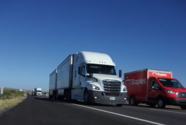
Reducing Roadkill: Safe Passages for Wildlife on Interstate-10 East
By Jessica Moreno, Conservation Science Director
One of the best things about doing roadkill surveys is watching the sunrise. During the monsoons, the sun breaks across the eastern horizon and lights up the moisture laden air and morning cloud cover with light and throws the foothills into brilliant color. The sun feels hopeful and the day new. The second-best thing is knowing that every datapoint is helping us make things better.
The 20-mile stretch of Interstate-10 (I-10) between Vail and Benson, east of Tucson, Arizona, divides the regionally important Rincon-Santa Rita-Whetstone Mountains Wildlife Linkage. This wildlife pathway is one of only a few – somewhat safe – crossing points across I-10 found between Tucson and New Mexico, and it encompasses several protected areas and important waters, including Davidson Canyon and Cienega Creek, making it critically important for desert wildlife in the face of climate change.

Thanks to aerial support provided by LightHawk, in February 2020 we were able to take to the air and photograph the project study area. The above photo is a view of the Rincon Mountains to the north with Cienega Creek and I-10 in the foreground. The Cienega Creek bridge, on the far center right, is one of the project’s wildlife camera monitoring sites, and cameras have been placed at each of the tributary drainages where they cross I-10. Roadkill surveys stretched from SR 83 to SR 90. Photo by Jessica Moreno, CSDP.
This wildlife pathway is protected partially by federally protected lands including Saguaro National Park, Rincon Wilderness, and Las Cienegas National Conservation Area. Pima County has invested in securing additional conservation lands in this linkage as mitigation under the Multi-Species Conservation Plan (MSCP), including Bar V Ranch, Cienega Creek Natural Preserve, Rancho Agua Verde, and Colossal Cave Mountain Park, which are managed under the Cienega Creek Management Plan.
However, I-10 cuts through this area of wildlife movement, resulting in more wildlife-vehicle collisions for large animals such as black bear, mule deer, whitetail deer, javelina, coyote, and mountain lion, as well as smaller species like box turtles, opossum, Antelope jackrabbit, white-nose coati, raccoon, badger, and bobcat. It also serves as a potential movement area for jaguars and ocelots. Existing culverts and right of way fencing are not currently adequate at reducing wildlife-vehicle collisions or ensuring safe wildlife passage in this area. Future growth and increases in traffic volumes will only worsen the frequency of vehicle-wildlife collisions.
Since 2006, several qualitative assessments and reports have been produced that highlight the area’s importance for wildlife movement, but there has not been a study that has collected data to build a high accuracy model of wildlife movements and roadkill locations along this corridor. With the lack of such a product, nothing has been done on the ground to reduce wildlife-vehicle collisions and to improve safe wildlife passage by employing effective mitigation structures like winged highway fencing or wildlife overpasses. The Coalition for Sonoran Desert Protection, in conjunction with partners, is spearheading the effort to collect data to provide the information necessary to make this stretch of I-10 a safer passage for both wildlife and people in this important corridor.

Raynor VanDeven captured this photo of a mule deer near one of our culvert study sites under I-10, just east of Davidson Canyon, with bright tail lights on the highway above appearing to streak across the night sky. He uses a custom built wildlife camera trap to gather these professional photos. Raynor’s work has been a tremendous contribution to this project!
In the spring of 2017, CSDP conducted comprehensive assessments and wildlife surveys of the nearly 80 existing concrete box culverts and metal plate pipe structures between milepost 277-302 (Houghton Road to SR90), with participants from several government, nonprofit, and community partners, including the Arizona Game and Fish Department, Cochise County, Pima County, Tucson Audubon Society, Sky Island Alliance, Defenders of Wildlife, and the Wildlands Network. Our results indicated that this wildlife linkage could be made safer for wildlife and motorists by 1) installing wildlife funnel-fencing to keep animals off the highway and to direct wildlife toward existing crossing points; 2) retrofitting and widening existing drainage culverts located in high volume areas; and 3) construction of an additional wildlife crossing between Cienega Creek and the railroad underpass near Empirita Rd Exit 292.
Roadkill surveys were part of the next phase of this effort: to gather data on roadkill hotspots, together with wildlife passage rates using wildlife cameras in the best existing culverts. We hope this data will inform State and County highway and wildlife officials on where to focus mitigation efforts to improve highway safety and minimize wildlife-vehicle collisions with site-specific wildlife funnel-fencing installation, existing culvert retrofits, and new wildlife crossing structures. Our results illustrate the need to implement changes and provides baseline information to evaluate the success of future mitigation measures.
Our Desert Roadies project began with a team of volunteers to help collect wildlife-vehicle mortality data on Interstate-10 between SR83 and SR90, east of Tucson. Desert Roadies volunteers worked in teams of 2-4 people, including myself, to conduct driving roadkill surveys. Observations were recorded by our notetaker with the GPS coordinates. Surveys were conducted in the morning, starting up to 30 minutes before sunrise, every week for 6 weeks during the monsoon season in 2019 and 2020, beginning in July, except when conditions were bad for visibility or driving such as rain, dust storms, or other low visibility weather. In addition to these formal roadkill surveys, we collected other data on iNaturalist.org from community members and personally investigated reports about black bear mortalities. We also requested ADOT records on reported animal-vehicle crashes in the study area. This data was analyzed separately.
Due to the onset of the Covid-19 pandemic in March 2020, carpooling with volunteers was no longer a safe option. So, we adapted as best we could by canceling the planned spring 2020 survey and having another monsoon season survey instead, which was conducted by myself and my family, Eddie Moreno (who is also a biologist experienced in roadkill surveys) and my two toddlers munching on donuts and “helping” look for animals from the backseat. This survey was done when the state was under curfew and lockdown, resulting in reduced traffic volumes. This likely was one reason for fewer observations of roadkill during this survey window.
Walking surveys are the ideal method for complete and accurate data. But safety concerns eliminated that option because we are using volunteer participation and this is a busy interstate highway with narrow right of ways. Therefore, the roadkill survey portion of this project was designed to be a broad-brush stroke only and we anticipated a small sample size. Recording categories of small, medium, large animals and/or by clade (reptile, bird, small/med/large mammal) are adequate for our purpose. Because of the project design, we have near zero detectability of small animals, and instead our target species are deer, bear, coyote, bobcat, gray fox, javelina, and those larger animals that the Arizona Department of Transportation consider most hazardous to drivers. The data will hopefully serve to provide a preliminary look at potential roadkill hotspot areas. For best accuracy 1) our GPS units had a one-button click to mark points quickly, 2) volunteers could also use maps and mileposts to confirm locations, 3) we analyzed the data in 1-mile segments, which better informs the fencing solution strategy and somewhat addresses imprecise location information, and 4) a staff biologist was always present to provide corroborating identification.
We completed two monsoon survey seasons for roadkill observations in 2019 and 2020, resulting in 78 data points of at least 14 different species. We were able to detect animals as small as a rock squirrel or cottontail rabbit. Skunks, raptors, and deer were not identified to specific species. All of our deer mortality observations (n=2) occurred between mileposts 296-297, near the Pima-Cochise County line. A hotspot of roadkill observations occurred between mileposts 291-295 (between Cienega Creek and Empirita Rd), in an area that coincides with a gap in available culverts and crossing points, and near several culvert locations between mileposts 283-287.

Coyotes, cottontail rabbits, and javelina were the most abundant roadkill species observed during our surveys. We also observed skunks, badger, opossum, raccoons, mule deer, jackrabbits, gray fox, domestic dogs, and raptors. Our 2020 monsoon survey occurred during a state lockdown at the beginning of the Covid-19 pandemic, and less traffic may be one reason for the reduction of roadkill during this survey period. Bruce Jacobsen created this “heat” map showing hotspots of our observations.

Our roadkill survey results for 2019 and 2020 monsoon survey seasons show hotspots around culverts east of Davidson Canyon, including an eastbound lane culvert that opens up to the median without a way across the westbound lane at milepost 285. Another larger hotspot appears between Cienega Creek and Empirita Road, which coincides with an area absent of available culverts for wildlife to use as crossing points.

The Arizona Department of Transportation (ADOT) collects crash records from police reports of vehicle crashes. Vehicle crashes caused by “animals” in recent years align with where we are seeing larger animals (deer, black bear) being hit most frequently on the interstate. Crash records can help make the case for increasing human safety by improving safe passage for wildlife – in addition to the goal of protecting healthy wildlife populations.
I-10 has been identified as a significant barrier to black bears in southern Arizona. In 2011, Todd Atwood et al published a study describing I-10 as a more significant barrier to functional gene flow for black bears than the U.S.-Mexico border, identifying I-10 as the dividing line between the Border subpopulation of black bears to the south, and the White Mountain subpopulation to the north. In our study area, these subpopulations meet and Romeo and Juliet romances unfold, ensuring healthy black bear populations in Arizona and in Mexico. For black bears, I-10 may be a barrier to gene flow as well as a “population sink” due to wildlife-vehicle deaths. This could pose a significant issue for the Border subpopulation, which additionally faces barriers to movement at the U.S.-Mexico border due to the construction of the border wall and other border-related infrastructure such as roads and lighting. Without safe passage both north of I-10 or south of the border, our southern Arizona black bears are at risk of genetic isolation and disappearing all together (what we call extirpation).
We have gathered four records of black bear mortalities in recent years, and three of these are verified with photos. These records indicate that the bears attempted to cross I-10 by following higher elevation ridgelines closely associated with the two largest underpass structures at Davidson Canyon and Cienega Creek. We also have animal track and camera trap data showing successful passage under I-10 at a few specific culverts. Most of our observations show bears moving south. April-May and August-September appear to be peak periods of activity for black bears in this area according to our data.
Black bears are just one example of the impact I-10 is having on native wildlife. In addition to large animals like bear, deer, and jaguar, smaller animals are at risk as well. Saguaro National Park has been monitoring a disturbing decline in “lost carnivores” over the last decade, including skunks, foxes, and badgers. Biologists are also concerned about the local disappearance of smaller range habitat specialist species affected by habitat fragmentation, including box turtles, Antelope jackrabbits, skunks, kit foxes, badgers, and white-nose coati. Increasing wildlife connectivity conditions for black bears and deer should allow struggling populations to repopulate from connected habitat areas and also benefit a wide array of other species.

In addition to our roadkill survey data, we were also able to collect four records of black bears killed by vehicle collisions in our study area. Bear roadkill occurred near mileposts 285 and 289-290, associated with the higher ridge lines close to Davidson Canyon and Cienega Creek. Deer collisions, on the other hand, were largely occurring near mileposts 296-297, where the landscape is naturally flatter.
With the data we’ve collected, we have solid evidence to back up the need for funding wildlife funnel fencing where it is most needed and make the case for new or improved wildlife crossings.
Read CSDP’s final project report to Arizona Game and Fish Department here.
(Please note: Photos of roadkill animals are included in the report)
Want to help?
Although collecting information on roadkill is not for the faint of heart, the data it provides is valuable. In the future, CSDP will be looking to continue our Desert Roadies program in more areas. In the meantime, folks can also document sightings of wildlife on roads in Pima County at https://www.inaturalist.org/projects/csdp-safe-passages.

Interstate 10 is a busy roadway, with 4 divided lanes and frequent commercial truck traffic. Adding wildlife funnel fencing to existing crossing structures is one simple solution to improve safe wildlife passages in this linkage. Photo by Matt Clark.
Acknowledgements
This work was made possible thanks to the time, effort, and skill of the following volunteers: Matt Clark, Sami Hammer, Bruce Jacobsen, Ken Lamberton, Eduardo Moreno, D’angelo Padilla, Raynor VanDeven, Althea Weeks, and Daisy Weeks.
We also want to thank Scott Sprague, Jeff Gagnon and Brit Oleson of the Arizona Game and Fish Department, and give special thanks to our collaborating partners: Myles Traphagen with The Wildlands Network and Brian Powell with Pima County Natural Resources, Parks and Recreation.
This project was funded in part by the Arizona Game and Fish Department Heritage Fund.
Coalition staffer presents on I-10 Safe Passages Project at International Conference on Ecology and Transportation
By Myles Traphagen, Borderland Programs Coordinator, Wildlands Network
Sacramento, California was the location of the tenth biennial International Conference on Ecology and Transportation (ICOET) held September 22 to 26th, 2019. Jessica Moreno, the Coalition for Sonoran Desert Protection’s Conservation Science Director, presented the “Safe Passages for Wildlife on Interstate-10 within the Rincon-Santa Rita-Whetstone Mountains Wildlife Linkage” project, made possible by a generous grant from the Arizona Game and Fish Department Heritage Fund.
Nearly 600 delegates from 19 countries attended the four-day conference held at the Hyatt Regency directly across the street from the California State Capitol building. The vast array of topics at the conference ranged from camera trapping workshops, wildlife crossing structure design, public policy, and the state of transportation ecology around the globe.
With nearly 4 million miles of roads in the United States, and the ever-increasing paving of new roads globally (estimated to total 16 million miles by 2050), the effects of mechanized human transport on wildlife, biodiversity, and highway safety are staggering. The constant, daily stress exerted upon wildlife and biodiversity by roads cannot be ignored. The Coalition for Sonoran Desert Protection is actively addressing this issue through a variety of projects, and the Safe Passages presentation made by Jessica at the ICOET Conference was the final presentation in the Connecting Plans to Action session, for action is our modus operandi.
The 20-mile stretch of Interstate 10 between the Highway 83 and first Benson exit is the focus of our project. It’s obvious to anybody who has driven through this stretch that the numerous drainages and arroyos, like Davidson Canyon and Cienega Creek (which encompass several protected areas and important waters in the eastern Sonoran Desert), provide a natural travel corridor for animals that migrate between the Sky Island mountains north and south of I-10. This area has been a frequent zone of wildlife vehicle collisions. It’s no accident that these unfortunate “accidents” occur, because the Arizona Wildlife Linkages Assessment identified several wildlife corridors that cross right through here. This underscores the perils of the linear infrastructure like roads, railways, power lines and canals that increasingly dominate our modern world.
Now in Phase II, the I-10 Safe Passages project is using wildlife camera monitoring and roadkill surveys, along with community science engagement, to gather species-specific baseline data on wildlife passage rates and roadkill hotspots. We couldn’t do this important work without our dedicated volunteer team of “Desert Roadies” to help us with the driving surveys. Preliminary results, including a black bear mortality on August 23rd at mile marker 289 at Cienega Creek, have already begun to identify optimum locations for wildlife funnel-fencing installation, existing culvert retrofits, and new wildlife crossing structures. These data will inform State and County highway and wildlife officials on where to focus mitigation efforts to improve highway safety and minimize wildlife-vehicle collisions, and to provide justification for project funding.
In the US alone, it is estimated that there are between one and two million large animal wildlife vehicle collisions a year with hundreds of human fatalities as a result. The science of Road Ecology is attempting to reduce these occurrences by using crash analysis and GIS modeling of landscape variables that naturally funnel animals towards point specific places in their daily and seasonal movements. Progress is being made in identifying these places (like along I-10) where the greatest likelihood of wildlife collisions is predicted to occur.
With the data collected from the I-10 Safe Passages Project, we can identify and quantify wildlife vehicle collision hotspots and plan for and modify build-out plans to mitigate and respond accordingly to reduce these conflicts. In the case of the proposed Interstate 11, we support using avoidance and not building it in the first place! In the age of “Super-Commuters,” a term which the Director of the California Department of Fish and Wildlife used to describe drivers who spend two hours each way traveling to and from work, we need to rethink our approach to highway construction and proactively mitigate for and modify the design and building of roads. To learn more about how you can help by volunteering or donating, visit us here. Keep an eye out for wildlife and drive slower, safer and less when you can.

CSDP Conservation Science Director Jessica Moreno and Myles Traphagen, Borderlands Program Coordinator with Coalition member group Wildlands Network, at the International Conference on Ecology and Transportation in Sacramento, CA in September 2019.

CSDP Conservation Science Director Jessica Moreno presents on the Coalition’s new I-10 Safe Passages project, funded by the Arizona Game and Fish Department Heritage Fund.
Opposition to any proposed interstate in Avra Valley grows
The recently convened I-11 Joint Stakeholder Community Planning Group has released a press release and position statement opposing any proposed route for Interstate 11 in Avra Valley. The Coalition for Sonoran Desert Protection is a proud leader of this new community stakeholder group. The full press release is below:
Citizens Convened by Federal and State Highway Departments Strongly Oppose Highway in Avra Valley
Stakeholders find Common Ground in Downtown Route to Create a Sustainable City
Arizona Department of Transportation (ADOT) and the Federal Highway Administration (FHwA) recently convened representatives of several stakeholder organizations in a process to explore two alternative routes for the proposed Interstate 11 through Pima County. Stakeholders have developed a consensus position that re-designing I-10 and I-19 to accommodate co-location with I-11 could have a positive effect on downtown revitalization, while stating strong opposition to an “I-10 bypass” in Avra Valley. See letter here. “A freeway that borders Tucson Mountain Park, Tohono O’odham tribal lands, Saguaro National Park, and Ironwood Forest National Monument makes absolutely zero sense,” stated Carolyn Campbell, Executive Director of the Coalition for Sonoran Desert Protection. “The direct and cumulative effects of a freeway to these natural and cultural iconic places of the Sonoran Desert simply cannot be mitigated. This route should not be under consideration.”
Stakeholders believe that there are shortcomings associated with the federal review process that focuses on new highway construction. However, “we believe that there could be a significant opportunity to address some of the historic negative consequences that resulted from the construction of I-10,” said Gene Einfrank, Menlo Park Neighborhood Association President. “The building of I-10 physically divided our community and diminished the quality of life of our downtown and other neighborhoods along the highway. Instead of simply adding new lanes to our existing highway, we should consider redesigning portions of it—either going underground or suspended—so that we can reconnect our city.”
Moreover, stakeholders encourage a broader look at future transportation options, focusing on changes to the management of the existing highway to reduce congestion, including pricing, scheduling, and other programs; technologies that improve traffic flows; and enhancements to the rail system, including light rail and intermodal transportation.
The group recommends ADOT and FHwA refer to the I-11 Super Corridor study final document, which was submitted to ADOT in 2016, to draw inspiration on a comprehensive design. The Sustainable Cities Lab, hosted at the UA College of Architecture, Planning and Landscape Architecture, completed this transdisciplinary study on the I-11 corridor along with Arizona State University and University of Nevada, Las Vegas. UA’s study area focused on opportunities from Marana to south of downtown Tucson. Their outcomes incorporate the addition of light and heavy rail, walking, cycling, new technology for controlling traffic as well as incorporating alternative forms of energy production and transportation.
Take Action: Attend public meetings about proposed Interstate 11!
April 13, 2017
UPDATE: The Coalition submitted an official comment letter on the I-11 Corridor Alternatives on May 31. Check it out here and feel free to quote our letter or use any of our language to help with your comments.
Mark your calendar! Save the date! And get ready to voice your opposition to any proposed interstate that goes through Avra Valley!
The Arizona Department of Transportation and the Federal Highways Administration are holding a series of public meetings in May to discuss their corridor alternatives for a new interstate between Nogales and Wickenburg. We are opposed to Corridor Alternatives C & D which go right through Avra Valley…and right next to Saguaro National Park and Ironwood Forest National Monument.
Do you think we should construct a new interstate in between our treasured Saguaro National Park and Ironwood Forest National Monument?
It is well-established that new interstates bring with them new development, new roads, and more traffic. They are not stand-alone pieces of infrastructure. They come with exits, gas stations, frontage roads, and all kinds of new development. They also have negative impacts on viewsheds, natural quiet, dark skies, and other wilderness values.
Avra Valley is a biologically-rich part of our region with significant protected open space, wildlife linkages, and mitigation lands. Avra Valley is located right in between Pima County-owned Tucson Mountain Park and national treasure Saguaro National Park to the east and Ironwood Forest National Monument and the Tohono O’odham Nation to the west. It also contains mitigation lands managed by the Bureau of Reclamation for impacts from the Central Arizona Project canal, open space lands owned by Pima County and the Regional Flood Control District, and the Santa Cruz River. A new interstate through all of these protected lands would be devastating and irreversible.
First, can we count on you to attend one of these public meetings and voice your opposition to Corridor Alternatives C & D through Avra Valley?
There are two meetings in the Pima County area, and four more in other parts of southern Arizona.
Tuesday, May 2, 5-7pm
Arizona Riverpark Inn, 777 W. Cushing St., Tucson
Wednesday, May 3, 5-7pm
Marana Middle School – Cafeteria, 11285 W. Grier Road, Marana
For a full list of all the public meetings and more information, head to the project website at http://i11study.com/Arizona/Meetings.asp
For a map of the corridor alternatives being presented at these public meetings, click here.
Second, will you please submit an official public comment opposing Corridor Alternatives C & D through Avra Valley? The public comment period is April 28-June 2, 2017.
Comments can be submitted by email to: I-11ADOTStudy@hdrinc.com or at a new dedicated comment website: www.i11comment.com
Verbal comments can be left at this phone number: (844) 544-8049
Comments can also be mailed to:
Interstate 11 Tier 1 EIS Study Team
c/o ADOT Communications
1655 W. Jackson St., Mail Drop 126F
Phoenix, AZ 85007
Need some talking points to get your started on your comments? Feel free to use these and make them your own:
- New interstates bring with them new development, new roads, and more traffic. They are not stand-alone pieces of infrastructure. They come with exits, gas stations, frontage roads, and all kinds of new development. They also have negative impacts on viewsheds, natural quiet, dark skies, and other wilderness values. It is unacceptable to locate a new interstate with this many impacts next to a national park and a national monument.
- Avra Valley is home to a rich mosaic of biologically-important lands, including a national park and a national monument on either side. The proposed Interstate 11 in southern Arizona should use the existing Interstate 10 corridor.
- We need to keep our public lands and wildlife linkages intact. Saguaro National Park is a national treasure that is already becoming increasingly isolated due to development pressure from Tucson and Marana to the east. Constructing a new interstate west of this national park would doom wildlife there forever.
- Should there be a proven need for expanded capacity, making improvements to the existing Interstate 10 corridor is the best alternative to manage increased traffic volumes in southern Arizona. All transportation options also need to be investigated, including an expanded rail corridor between Tucson and Phoenix and multi-modal transportation solutions generally.
Want to read the Coalition’s comment letter? Check it out here and feel free to quote us or use any of the language in our letter to help you with yours!
Thank you for speaking out and using your voice to make a difference!
Questions? Please give us a call at (520) 388-9925 or send us an email at admin@sonorandesert.org.