Posts Tagged ‘Sonoran Desert Conservation Plan’
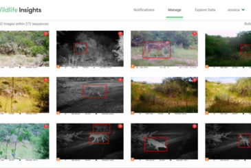
Tucson-Tortolita Mountains Wildlife Linkage: The Latest Data and Looking Ahead
Last month we shared that we expanded this project in 2022, with cameras on either side of I-10 between the Tucson Mountains and Tortolita Mountains, and six more planned to be placed in 2023. Here are some details on what we’ve found so far!
Our project is comparing five study areas, each with four cameras placed at least 200m apart. These areas are shown in the map below: Private lands in the northern Tucson Mountain range (1), Los Morteros & Rattlesnake Pass (2), El Rio Preserve (3), the Santa Cruz River (4), and Pima County Conservation lands east of Interstate 10 called Cascada (5). These study areas make up a large part of the Tucson-Tortolita Wildlife Linkage, and each has different topography, elevation, distance to water, and other unique habitat features.
Our results show that each study area is dominated by different species, but there are common species throughout, namely mule deer, coyote, bobcat, javelina, gray fox, and cottontail rabbit. Mountain lions have only been observed on Private lands, while kit fox and badger have only been photographed on Cascada lands. El Rio is thus far the least diverse in species (it is also the smallest area and the most impacted by people), while Private lands have been the most diverse – unless you count individual bird species, and then the Santa Cruz River area has them all beat. In addition to the exciting kit fox discovery, other notable species include hooded and spotted skunks, raccoon, and Mexican free-tailed bats.
Working with Pima County, this data is already informing a project to build a wildlife ramp from the only accessible wildlife crossings near Avra Valley Road, to provide entry into the Santa Cruz River over the water levy. We are also working on gaining permanent protection for the Tortolita Preserve and planning a large wildlife bridge over I-10, and a smaller crossing structure at Rattlesnake Pass. These crossings are being designed specifically with mule deer, mountain lion, and bighorn sheep in mind, but will benefit many species.
Thank you to all of our volunteers that are instrumental to this work and to our many member groups and community partners that are collaborating on this multi-pronged project!
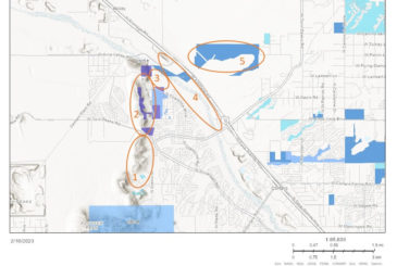
Pima County pursues new protected open spaces
Late last year, Pima County announced a slate of new protected open space acquisitions they are pursuing with the $2 million allocated for the acquisition of conservation land in the County’s 2022-2023 budget. The open space parcels include:
- A set of parcels next to the wildlife crossing over the CAP canal in Avra Valley;
- A set of private inholdings on the M-Diamond Ranch in the San Pedro River valley; and
- A small inholding on the Buckelew Farm in Avra Valley.
Want to learn more about these parcels? Head over to this Pima County memo that includes more details about each open space acquisition and maps of the parcels adjacent to the CAP canal wildlife crossing.
All of these new open space acquisitions are part of Pima County’s continued implementation of the Sonoran Desert Conservation Plan.
The latest on I-11: Lawsuit sees its first day in court
On Wednesday, January 25, 2023, U.S. District Judge John C. Hinderaker heard arguments on the federal government’s motion to dismiss a portion of our challenge to Interstate 11 filed in April 2022 in collaboration with the Center for Biological Diversity, Tucson Audubon Society, and Friends of Ironwood Forest. Big thanks to the 30 Coalition supporters that showed up to support us at the hearing.
According to a press release about the hearing, “The lawsuit says the agency failed to consider other transportation alternatives, such as rail, and sidestepped the required environmental review before approving the 280-mile-long highway between Nogales and Wickenburg. The planned interstate’s west option would plow through desert wildlands in rural Avra Valley and between Saguaro National Park and Ironwood National Monument. It would disturb hundreds of archaeological and cultural sites and spread invasive buffelgrass known to fuel wildfires.”
You can learn more at at a KVOA4 story that aired after the hearing and a KGUN 9 story that aired before the hearing. We will update you when we learn more about a timeline for Judge Hinderaker’s decision on the case.
Whatever his decision, we remain grateful for your support as we continue advocating against the West Option for Interstate 11 and for a connected and restored Sonoran Desert in southern Arizona for all.
Want to learn about the history of Interstate 11 and ways to get involved today? Head over to our comprehensive set of webpages (also found at the top of this page under the “Our Work” tab), including a history of the planning process, a thorough list of media articles, maps, and more.
SnapShot USA in full swing
The Snapshot USA project is a huge collaborative effort to sample mammal populations with camera traps across all of the United States. The study is designed to sample sites in all 50 states stratified across habitats and development zones (suburban/rural/wild/urban) with an objective of at least 400 “trap nights” (or days) per sub-project/ organization.
This year we were able to contribute camera data from 12 cameras in our Oro Valley study area, for the study period of September and October.
Despite a few challenges with vegetation growth creating lots of blank images, we contributed 3,208 photos of species including javelina, jackrabbits, coyotes, bobcats, mule deer, white-tail deer… and even a surprise black bear on the MALLOW camera! The entire effort has collected photos of 384 species at over 2,000 camera sites across the U.S.
As science papers come out of this data, we will share the results and findings with you, and we look forward to contributing again next year!
The first Tortolita BioBlitz was a huge success!
On Saturday November 19th, 46 participants made almost 700 observations of over 135 species!
The first Tortolita Preserve BioBlitz was a huge success! What a great way to share and explore this amazing open space!
We held seven small group outings during the BioBlitz, and all the participants enjoyed getting a chance to explore with guides from Arizona Master Naturalists, Arizona Game and Fish Department, the Coalition for Sonoran Desert Protection, and Tortolita Alliance. One of the guided walks headed by CSDP’s Jessica Moreno focused on identifying animals by scat and tracks. Species identified included Grey Fox, Mule Deer, Bobcat, Coyote, and even the tiny and industrious Kangaroo Rat! Another walk conducted by Jennie McFarland from Tucson Audubon Society and Steven Prager from Audubon Southwest yielded a list of fifteen species including a Ruby-crowned Kinglet; the first time this species has been documented here on E-Bird. Another highlight was the identification of Gregg’s Nightblooming Cereus happily existing in the understory of a Palo Verde.
In addition to the outings, many people worked hard collecting observations on their own. We had several people visiting the Tortolita Preserve for the first time and others new to iNaturalist making a big contribution to the success of the event. Identifying observations made by others is another area in which our group really contributed. We had people making identifications during the BioBlitz. This is such an important part of the outreach component of iNaturalist, so a big thanks to people who worked on identifications!
Check out the project:
Tortolita Preserve Fall BioBlitz · iNaturalist

Jessica Moreno leads a dawn wildlife track and sign survey for the Tortolita Preserve BioBlitz to a group of BioBlitzers. Sunrise really lights up those tracks! It was a cold start, but warmed up quickly.
Desert Fence Busters
Join us for our last Desert Fence Busters event for Winter 2023!
WHEN: 7:30am-2pm
WHERE: West Tucker Road, Avra Valley – more detailed directions will be given after you register
NOTES: Organizers will provide coffee and donuts/bagels in the morning and snacks, water, and Gatorade during break. No lunch will be provided. There will also not be a portable outhouse and camping will not be allowed (day-event only).
REGISTER TODAY at the Arizona Game and Fish Department website.
HOW TO SIGN UP: You will need to create an account with the Arizona Game and Fish volunteer portal (if you don’t have one already) and then sign up for this specific event.
1. After navigating to the event sign-up page, click the “Respond” button in the top right corner.
2. Click “Sign Up” to create an account and follow the required steps.
3. Once your account is created, including signing the volunteer registration form, you will be sent back to the main sign-up page. Scroll down below the photo to the section titled “Shifts.”
4. Click the “Respond Individually” button and sign up for the event (only one shift is available).
There are limited spots available so sign up as soon as you can!
Want to learn more about the Desert Fence Busters? Head over to our website for a recap of our events so far, including photo slideshows.
Pima County’s Open Space Conservation Acquisitions: An Overview
Pima County has invested heavily in acquiring conservation properties, especially in fulfilling the goals of the Sonoran Desert Conservation Plan. The County recently released a new report about all their open space conservation acquisitions. Along with providing a comprehensive overview of this decades-long program, the report specifically touches on the transparent public processes underlying the prioritization of eligible lands, funding mechanisms, and benefits these lands bring to the community.

This map from page 13 of the report shows the full suite of conservation lands in Pima County, including the open spaces owned or managed by Pima County in green and open spaces owned or managed by other jurisdictions (such as the Forest Service, National Park Service, etc.) in yellow.
You can check out the full report HERE.
Thank you for supporting our work as a partner and advocate for connected and robust protected open space in the Sonoran Desert!
Pima County releases 2019 Annual Report on Multi-Species Habitat Conservation Plan
In March 2020, Pima County released its fourth annual report on its Multi-Species Habitat Conservation Plan (MSCP). The full report can be found on the Pima County website HERE. According to the Executive Summary, six Pima County capital improvement projects and 52 private development projects were “covered” by the MSCP in 2019. While these projects cumulatively had 196.8 acres of impact to the habitat of vulnerable wildlife species, the MSCP required 767.7 acres of mitigation to offset these impacts.
Some other highlights from the report include:
- The Regional Flood Control District reported that 94.5% of applicants avoided impacting regulated riparian habitat.
- The Pima County Board of Supervisors approved several land-use policies that promote reuse or infill instead of sprawl.
- U. S. Fish and Wildlife Service approved a plan for augmenting populations of covered species on our mitigation lands, and another for managing properties along the San Pedro River.
- A new population of Gila topminnow was established in a stream on the County’s M Diamond Ranch.
- During 2019, the portfolio of potential mitigation lands increased by approximately 250 acres.
- Pima County staff, contractors, and volunteers mechanically removed or chemically treated approximately 1,470 acres of buffelgrass on County preserve lands.
- Office of Sustainability and Conservation staff made 623 separate observations on Covered Species; these were reported to the Arizona Game and Fish Department.
- County staff developed comprehensive monitoring protocols for seven monitoring elements, including upland habitat, water resources, landscape pattern change, invasive aquatic and plant species, off-highway vehicles, and climate.
- County staff in partnership with Tucson Audubon Society and the National Park Service established an additional 21 long-term vegetation and soils monitoring plots on County preserve lands.
New wildlife cameras generate spectacular photos
Thanks to a new partnership with volunteer, welder, and ecology student Raynor Vandeven, there are now four wildlife cameras out in the field with professional photography equipment capturing images of Sonoran Desert wildlife. These cameras are located in an area along the proposed I-11 route, in the Tucson Mountains, near the Oracle Road wildlife crossings, and in the I-10 East wildlife linkage area.
We are so grateful to Raynor for his willingness to share these images with the Coalition and can’t wait to start sharing more of them with you in the weeks and months ahead!
(Note: the photos below are examples of Raynor’s wildlife photography and were not taken in the locations described above. )
Coalition staffer presents on I-10 Safe Passages Project at International Conference on Ecology and Transportation
By Myles Traphagen, Borderland Programs Coordinator, Wildlands Network
Sacramento, California was the location of the tenth biennial International Conference on Ecology and Transportation (ICOET) held September 22 to 26th, 2019. Jessica Moreno, the Coalition for Sonoran Desert Protection’s Conservation Science Director, presented the “Safe Passages for Wildlife on Interstate-10 within the Rincon-Santa Rita-Whetstone Mountains Wildlife Linkage” project, made possible by a generous grant from the Arizona Game and Fish Department Heritage Fund.
Nearly 600 delegates from 19 countries attended the four-day conference held at the Hyatt Regency directly across the street from the California State Capitol building. The vast array of topics at the conference ranged from camera trapping workshops, wildlife crossing structure design, public policy, and the state of transportation ecology around the globe.
With nearly 4 million miles of roads in the United States, and the ever-increasing paving of new roads globally (estimated to total 16 million miles by 2050), the effects of mechanized human transport on wildlife, biodiversity, and highway safety are staggering. The constant, daily stress exerted upon wildlife and biodiversity by roads cannot be ignored. The Coalition for Sonoran Desert Protection is actively addressing this issue through a variety of projects, and the Safe Passages presentation made by Jessica at the ICOET Conference was the final presentation in the Connecting Plans to Action session, for action is our modus operandi.
The 20-mile stretch of Interstate 10 between the Highway 83 and first Benson exit is the focus of our project. It’s obvious to anybody who has driven through this stretch that the numerous drainages and arroyos, like Davidson Canyon and Cienega Creek (which encompass several protected areas and important waters in the eastern Sonoran Desert), provide a natural travel corridor for animals that migrate between the Sky Island mountains north and south of I-10. This area has been a frequent zone of wildlife vehicle collisions. It’s no accident that these unfortunate “accidents” occur, because the Arizona Wildlife Linkages Assessment identified several wildlife corridors that cross right through here. This underscores the perils of the linear infrastructure like roads, railways, power lines and canals that increasingly dominate our modern world.
Now in Phase II, the I-10 Safe Passages project is using wildlife camera monitoring and roadkill surveys, along with community science engagement, to gather species-specific baseline data on wildlife passage rates and roadkill hotspots. We couldn’t do this important work without our dedicated volunteer team of “Desert Roadies” to help us with the driving surveys. Preliminary results, including a black bear mortality on August 23rd at mile marker 289 at Cienega Creek, have already begun to identify optimum locations for wildlife funnel-fencing installation, existing culvert retrofits, and new wildlife crossing structures. These data will inform State and County highway and wildlife officials on where to focus mitigation efforts to improve highway safety and minimize wildlife-vehicle collisions, and to provide justification for project funding.
In the US alone, it is estimated that there are between one and two million large animal wildlife vehicle collisions a year with hundreds of human fatalities as a result. The science of Road Ecology is attempting to reduce these occurrences by using crash analysis and GIS modeling of landscape variables that naturally funnel animals towards point specific places in their daily and seasonal movements. Progress is being made in identifying these places (like along I-10) where the greatest likelihood of wildlife collisions is predicted to occur.
With the data collected from the I-10 Safe Passages Project, we can identify and quantify wildlife vehicle collision hotspots and plan for and modify build-out plans to mitigate and respond accordingly to reduce these conflicts. In the case of the proposed Interstate 11, we support using avoidance and not building it in the first place! In the age of “Super-Commuters,” a term which the Director of the California Department of Fish and Wildlife used to describe drivers who spend two hours each way traveling to and from work, we need to rethink our approach to highway construction and proactively mitigate for and modify the design and building of roads. To learn more about how you can help by volunteering or donating, visit us here. Keep an eye out for wildlife and drive slower, safer and less when you can.

CSDP Conservation Science Director Jessica Moreno and Myles Traphagen, Borderlands Program Coordinator with Coalition member group Wildlands Network, at the International Conference on Ecology and Transportation in Sacramento, CA in September 2019.

CSDP Conservation Science Director Jessica Moreno presents on the Coalition’s new I-10 Safe Passages project, funded by the Arizona Game and Fish Department Heritage Fund.