
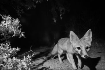
Kit Fox: CSDP Photographs Another First
By Jessica Moreno, Conservation Science Director It’s late morning in early May when my phone buzzes with a text message from my friend and long-time Desert Monitor Josh Skattum. It’s […]
Join us in removing old fencing and improving wildlife connectivity in Avra Valley!
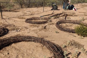
Join us this week to remove old fencing and improve wildlife connectivity between the Tucson Mountains and the Tohono O’odham Nation! Background This past December, over 65 volunteers came together […]

SR86 Wildlife Bridges move to siting and design phase
In January 2022, a group of people from Arizona Game and Fish Department, Arizona Department of Transportation, the Tohono O’odham Nation, and the Coalition for Sonoran Desert Protection conducted a […]

Avra Valley Fence Removal Volunteer Day a Big Success!
On December 11, 2021, a group of local organizations and state/federal agencies came together to celebrate National Public Lands Day by holding a Fence Removal Volunteer Day in Avra Valley. […]

Updates from the El Rio Riparian Preserve
By Janine Spencer-Glasson, Friends of El Rio Preserve The Santa Cruz River serves as an important resource for migrating birds in the southwestern United States. Migrating birds depend upon riparian […]

Pima County releases 2019 Annual Report on Multi-Species Habitat Conservation Plan
In March 2020, Pima County released its fourth annual report on its Multi-Species Habitat Conservation Plan (MSCP). The full report can be found on the Pima County website HERE. According […]
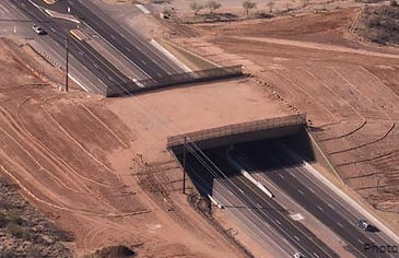
The latest monitoring data from the Oracle Road wildlife crossings!
Arizona Game and Fish Department (AGFD) just released the latest and greatest monitoring data from the Oracle Road wildlife overpass and underpass. This represents FOUR FULL YEARS of monitoring these […]

New wildlife cameras generate spectacular photos
Thanks to a new partnership with volunteer, welder, and ecology student Raynor Vandeven, there are now four wildlife cameras out in the field with professional photography equipment capturing images of […]

Oracle Road wildlife crossings featured on FOX10 Drone Zone segment
The Oracle Road wildlife crossings were recently featured on TV station FOX10’s Drone Zone segment in Phoenix. Check out this 3+ minute segment to see some amazing drone footage of […]

New report on I-11 calls it a “white elephant” and “unnecessary”
On August 8, 2019, the Center for American Progress released a new report on the proposed Interstate 11 as part of its “White Elephant Watch” series, which “profiles projects that […]