Why are these wildlife crossings needed?
How were these wildlife crossings funded?
How did you decide where to put them?
How was the size of the wildlife bridge and wildlife underpass determined?
How were the wildlife crossings built?
Could the wildlife crossings become traps for animals?
How will the animals know to use the crossings?
Will you be monitoring the crossings after they are built?
Will the land on either side of the wildlife crossings be protected?
Will people be using these to cross the road?
Why are these wildlife crossings needed?
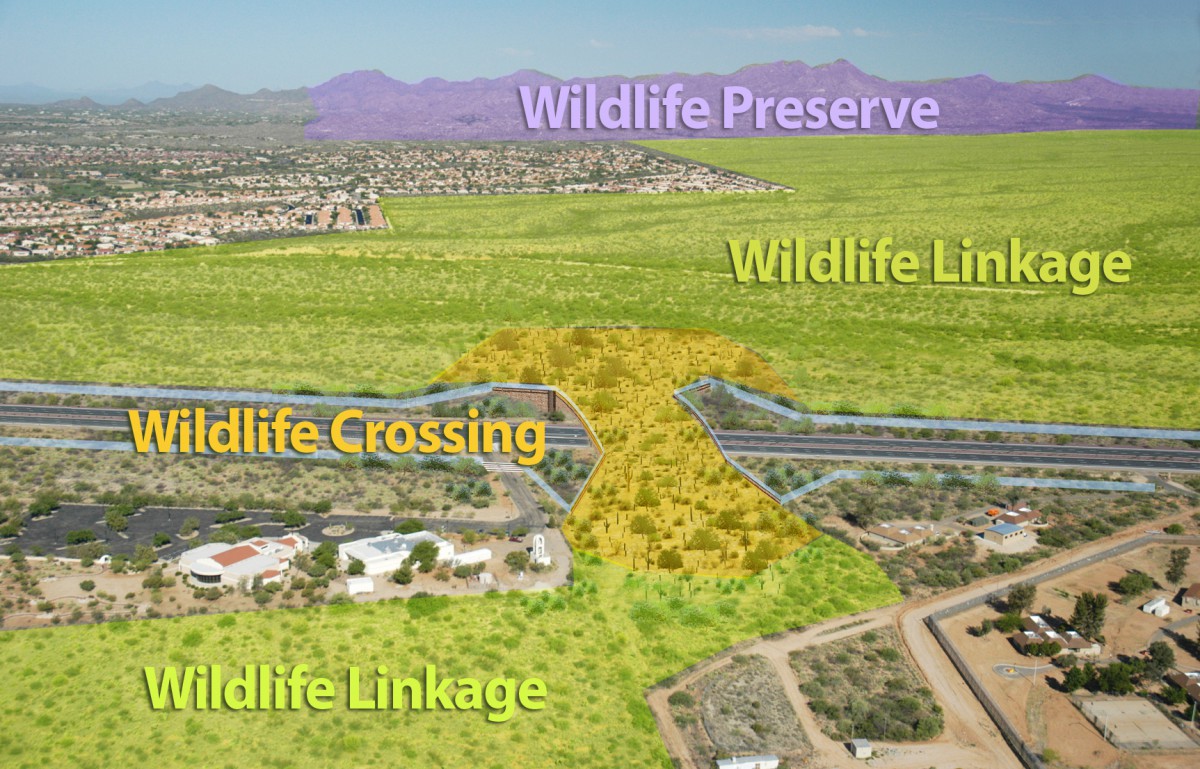
Wildlife crossings are a critical part of protecting the Tortolita-Santa Catalina Mountains wildlife linkage. A wildlife linkage connects two large, separate wildland areas, or habitat blocks, and allows animals to move from one area to another to find food, rest, mate and successfully raise young. Unless wildland habitat blocks are connected, they become isolated islands. Over time, genetic diversity declines and entire species can die out in the isolated areas.
Many wildlife linkages around Tucson, including this one, are threatened by habitat fragmentation, where large undeveloped areas are broken apart into ever smaller pieces by roads, utilities, homes, and businesses. This is especially true for growth areas where new housing and commercial developments can put pressure on native wildlife. Once connected wildland habitat blocks are now either disconnected or tenuously connected across the landscape.
In this case, the wildland habitat blocks are the Tortolita Mountain Park (owned and managed by Pima County) and the Santa Catalina Mountains (mostly owned and managed by the U.S. Forest Service). Oracle Road runs north-south, perpendicular to the east-west trending wildlife linkage between the Santa Catalina and Tortolita Mountains, impairing habitat connectivity across the entire linkage. When the Arizona Department of Transportation announced plans to widen this section of Oracle Road from four to six lanes, they recognized a unique opportunity to include landscape-scale wildlife crossings into the project. This produced significant cost savings since the crossings were incorporated into the overall design and construction schedule.
We are working with all our partners to ensure that adequate open space is protected on either side of the wildlife crossing structures. Some of the land, like Catalina State Park, is already protected. But some of it, like a few checkerboard parcels of State Trust Land on either side of the crossing structures, remain in need of better protection. We continue to work with Pima County, the Town of Oro Valley, the Village of Catalina, and the Arizona State Land Department to make sure an adequate wildlife linkage design is included in all planning efforts and maps for this area. (Return to top)
How were these wildlife crossings funded?
Pima County voters approved the Regional Transportation Authority (RTA) Plan and a ½ cent sales tax to fund it, on May 16, 2006. It is a 20-year plan. The RTA has four distinct funding categories: Roadway Improvement ($1.2 billion); Safety ($180 million); Environmental and Economic Vitality ($115 million); and Transit ($534 million). $45 million is allocated for wildlife linkage projects under the Environmental and Economic Vitality category. This voter-approved money is restricted funding specifically for wildlife linkage projects and cannot be used for other purposes. The Oracle Road wildlife crossing structures were built by the Arizona Department of Transportation using this RTA funding.
A multi-jurisdictional Wildlife Linkages Working Group recommends projects to the RTA Board, comprised of elected leaders from the local jurisdictions. The Board decides how to allocate the $45 million in wildlife linkage funding to specific projects. Cities, towns, and state agencies can present proposals to the Working Group and the Working Group decides whether or not to recommend the proposal. For more information on other wildlife linkage projects that have been funded by the RTA, visit the Wildlife Linkages Working Group website here. The original proposal submitted to the Working Group for the Oracle Road wildlife crossings can be found here. (Return to top)
How did you decide where to put them?
The best available scientific research (including surveys for wildlife killed in or along the roadway), property ownership, and existing topography were all factored into the decision about where to put the Oracle Road wildlife bridge and wildlife underpass.
In 2006, the Arizona Game and Fish Department and Arizona Department of Transportation completed a statewide Arizona Wildlife Linkages Assessment. This report studied all of Arizona’s main wildlife linkages and prioritized those that are most threatened by new roads and development. The Santa Catalina-Tortolita Mountains Wildlife Linkage, which Oracle Road cuts in half, was identified as one of the most threatened wildlife linkages in all of Arizona.
Next, a team of scientists based at Northern Arizona University created detailed maps of the top 16 most threatened wildlife linkages, including the Santa Catalina-Tortolita Mountains Wildlife Linkage. Collectively, this project is called “Arizona’s Missing Linkages.” The goal of this project is to, “…identify and map multi-species corridors that will best maintain wildlife movement between wildland blocks, as well as highlight specific planning and road mitigation measures required to maintain connectivity in these corridors.” The scientists assessed the habitat needs of a wide range of wildlife species, existing washes and movement pathways, and property ownership to create a map of the wildlife linkage. The report about the Santa Catalina-Tortolita Mountains wildlife linkage can be found here.

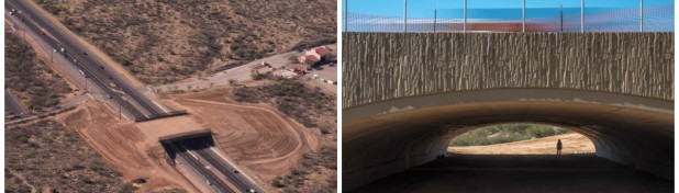
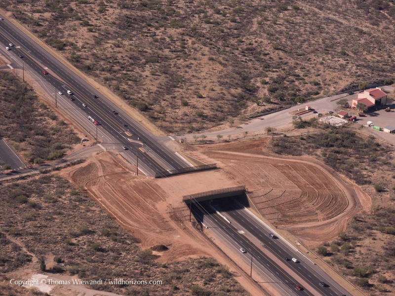
The Arizona Department of Transportation combined all of the available scientific information about this wildlife linkage with actual roadkill data from the Arizona Game and Fish Department and the non-profit organization Sky Island Alliance. The wildlife underpass was located in an existing wash area and the wildlife bridge takes advantage of an existing hill on the east side of the road. This reduced the cost of both crossings significantly since much less earth had to be removed and/or moved to construct them. The land on either side of both crossings is owned by Catalina State Park, Pima County, or the Arizona State Land Department. This ensures that there will continue to be protected open space for wildlife to move through on either side of the crossing structures. (Return to top)
How was the size of the wildlife bridge and wildlife underpass determined?
The sizes of the wildlife bridge and wildlife underpass were based on the best available scientific research on what animals will actually use to cross a roadway.
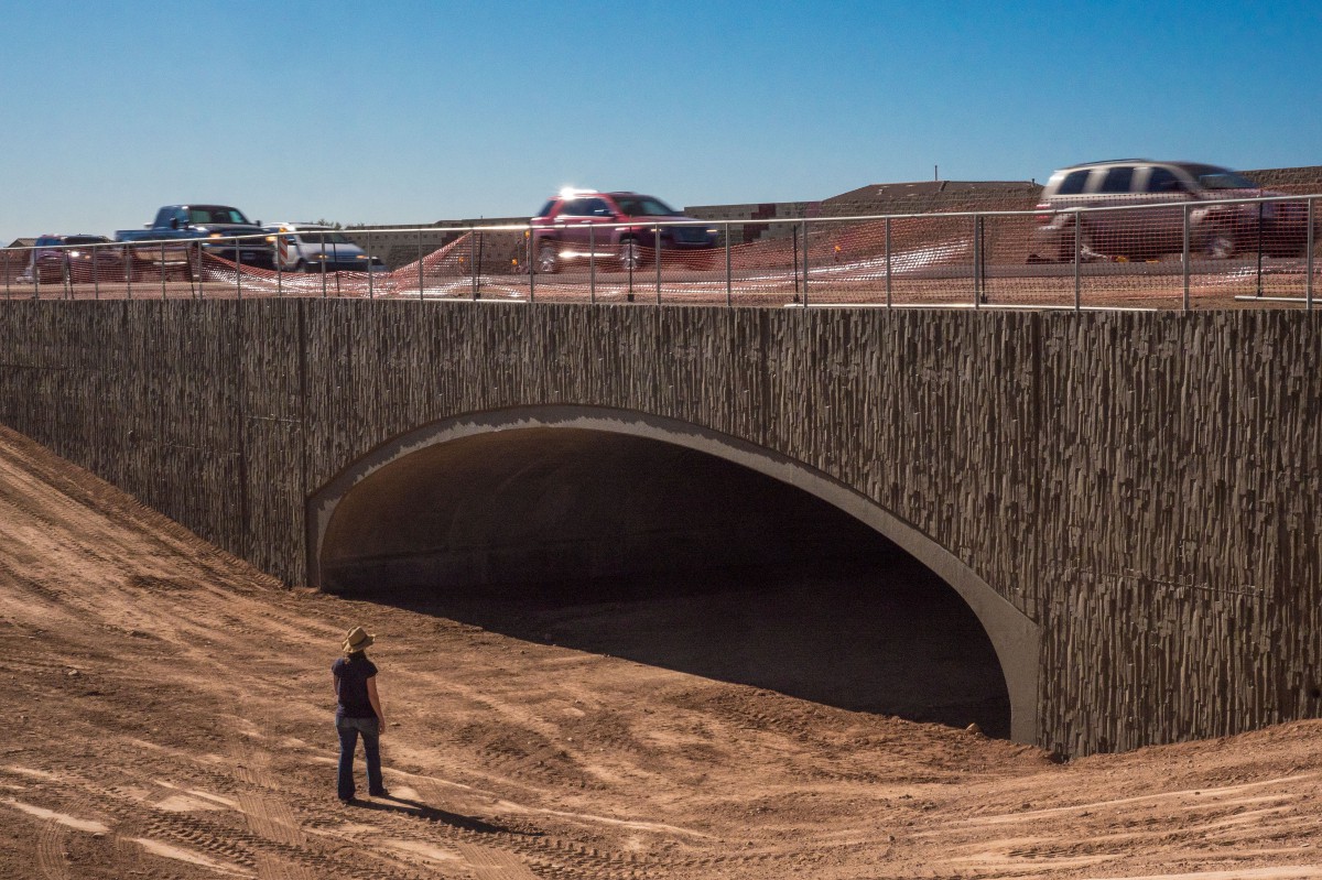
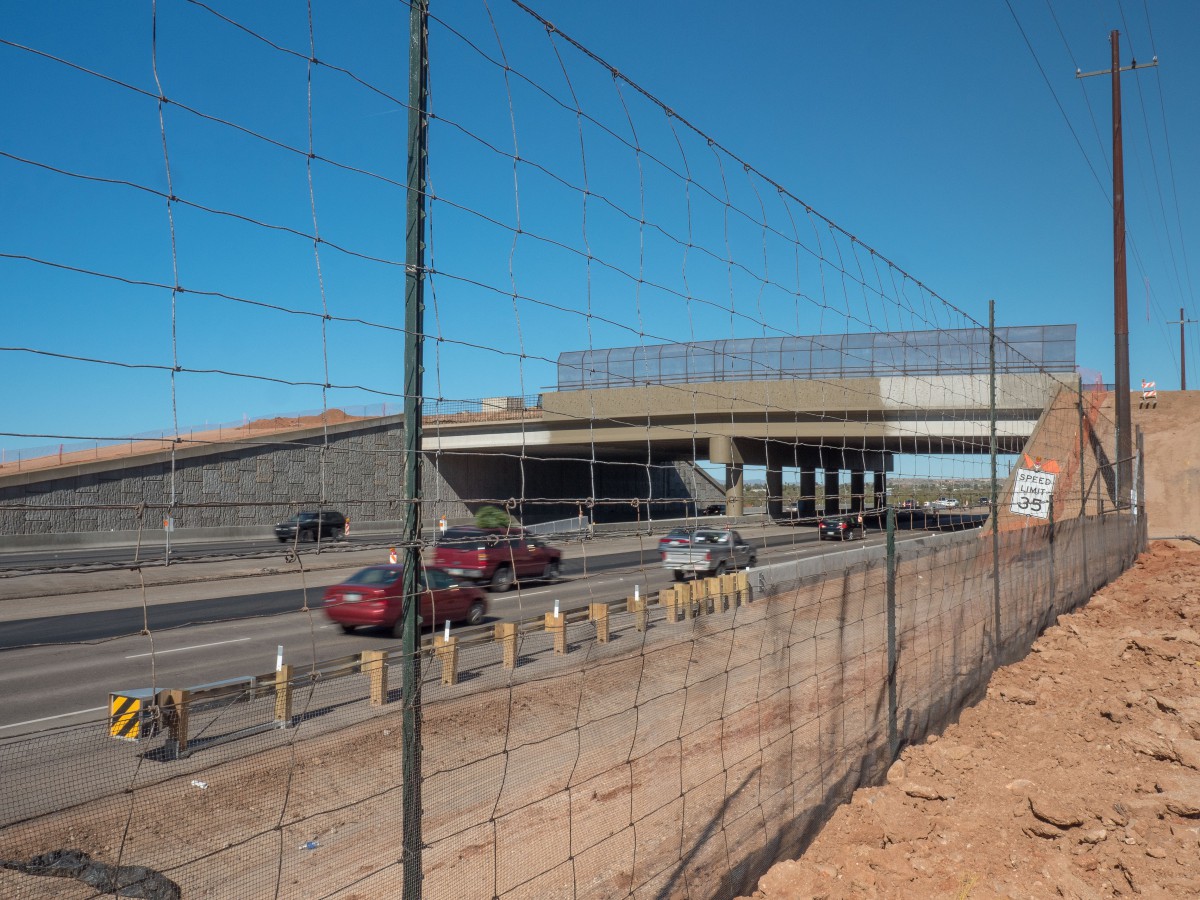
The design and width of the wildlife bridge were based on research on other wildlife bridges that have been built all over the world. There must be sufficient space on a wildlife bridge to provide plants that create food sources and shelter for a wide range of species. Some animals, such as bighorn sheep, require extra space and more open visual sight-lines to feel safe and comfortable using a bridge to cross above a busy, bright roadway below. The Oracle Road wildlife bridge is 150 feet wide, the minimum necessary to provide shielding from the sights, smells and sounds of the roadway below.
Although there is an acclimation period, wildlife eventually learn to use properly constructed wildlife bridges and underpasses. This has been proven in many types of ecosystems all over the world. Large ungulates such as deer and bighorn sheep often have a strong preference to go over a roadway. In Arizona, great success has been shown for three wildlife bridges constructed in 2011 specifically for desert bighorn sheep to cross between habitats located on either side of US 93 near the Hoover Dam. For more information on this project, go here.
For animals that prefer to go under a roadway, the crossing has to have a large enough “openness ratio.” The openness ratio of a crossing is calculated by using the following formula:
Openness ratio = (Crossing height x Crossing width)/Crossing Length
(measurements must be calculated in METERS)
According to the Arizona Game and Fish Department, the minimum openness ratio for large mammals (such as deer, mountain lion, coyotes, and bobcats) is 0.75 but preferably 0.9. The openness ratio of the Oracle Road underpass is 0.96 (15.24 m wide (50 feet) by 3.66 m high (12 feet) by 57.91 m long (190 feet)).
More information about the research behind wildlife crossing design can be found here. (Return to top)
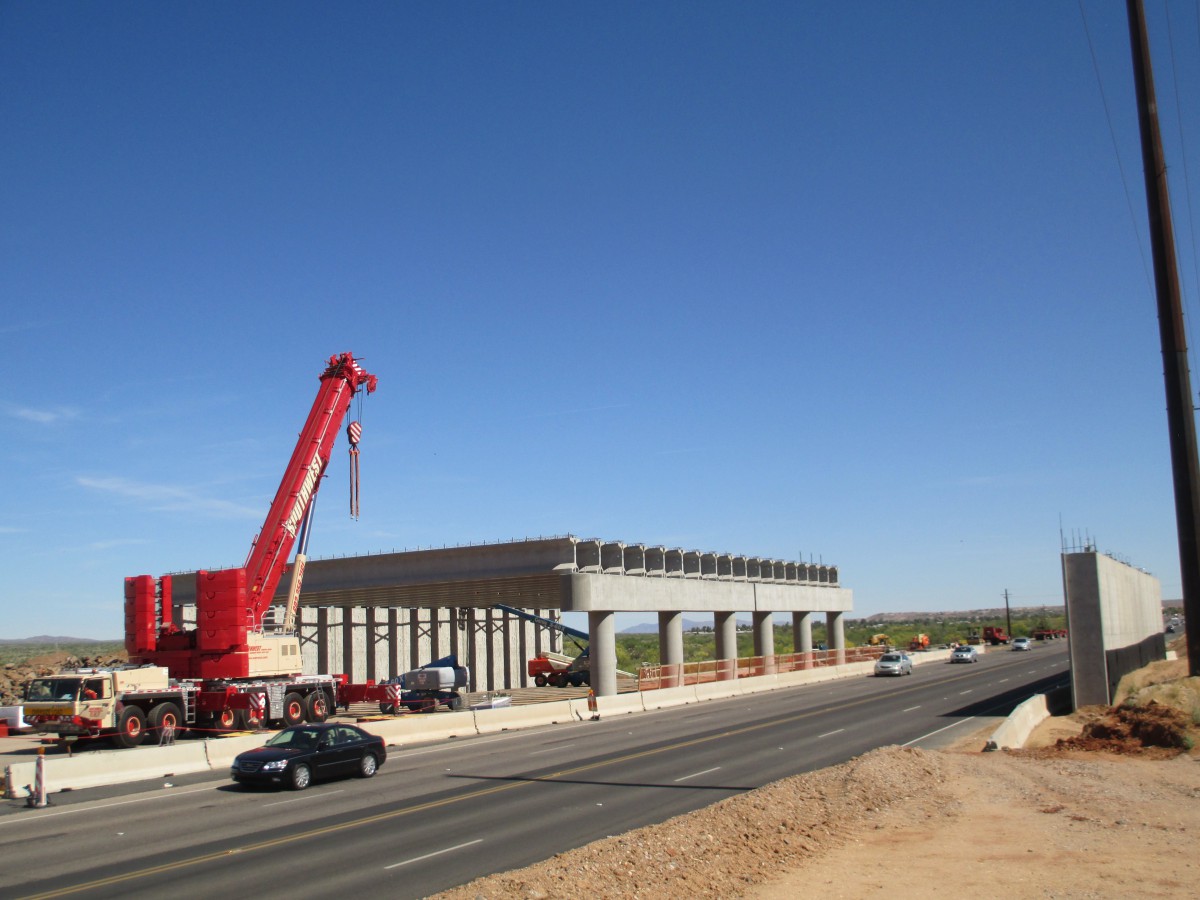
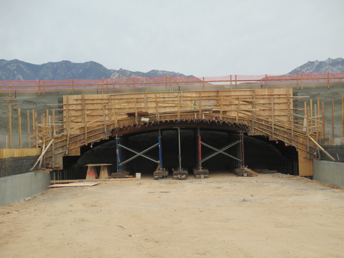
How were the wildlife crossings built?
The wildlife crossings were built by the Arizona Department of Transportation and the project contractor Granite Construction. The crossings were integrated into the larger construction project that widened Oracle Road from four to six lanes. To learn more about the larger construction project, you can visit the ADOT project page here. ADOT also has a fact sheet about the wildlife crossings here.(Return to top)
Could the wildlife crossings become traps for animals?
Thorny shrubs such as hackberry, rock piles, and other features spaced at intervals within and at the ends of the crossing areas will provide protection for smaller wildlife and allow them to use the crossings more safely.
In Banff National Park in Canada, researchers conducted a study of 28 wildlife crossing structures across the Trans-Canda Highway. They were interested in whether ungulates (such as deer) were being preyed upon more frequently near the wildlife crossings. They did not find any evidence that predators changed their behavior near wildlife crossings or that higher numbers of ungulates were killed near the wildlife crossings. The full abstract of the research paper can be found here. (Return to top)
How will the animals know to use the crossings?
Carefully designed wildlife fencing was installed on both sides of Oracle Road to “funnel” wildlife towards the crossings. The 8-feet high fencing consists of main square-mesh panels with a fine-mesh panel attached to the lower portion of the fence. The fence needs to be this high to prevent animals like deer from jumping over it. The fine-mesh panel prevents small mammals, snakes, and lizards from getting onto the roadway. The fence was also be buried 6 inches underground to discourage animals from burrowing underneath it. Fencing is a critical component of wildlife crossings and is very effective at directing wildlife to these safe passageways.
Where side roads meet Oracle Road, a carefully designed cattle guard was installed to discourage wildlife from accessing the roadway at these locations. If an animal does succeed in getting onto the roadway, the wildlife fence includes “jump-outs” which are essentially large hills of dirt built on the road side of the fence. Jump-outs allow an animal to safely leave the roadway and return to the safe side of the fence. Jump-outs do not allow animals to cross the fence onto the roadway. (Return to top)
Will you be monitoring the crossings after they are built?
Yes. The Arizona Department of Transportation and the Arizona Game and Fish Department have collaborated to include video and still cameras directly wired into each end of the crossing structures. In December 2015, the RTA funded a 4-year monitoring program spearheaded by AGFD which included video and still cameras, roadkill surveys, monitoring the movements of Sonoran Desert tortoises, and recommendations for adaptive management. The wildlife cameras were installed in April 2016 and are capturing both small and large animals approaching and using the structures. We are also collaborating with AGFD on the monitoring of the crossing approaches through our volunteer-driven Wildlife Camera project. All project partners are also working together to maintain the wildlife fencing, design and install educational signs near the crossings that discourage human use and give an overview of the project, and monitor vegetation on the crossings. For more information about post-construction monitoring and to view video footage and still photos of wildlife using the crossings, visit our monitoring webpage here. (Return to top)
Will the land on either side of the wildlife crossings be protected?
Yes. We have worked in various ways and with multiple partners and jurisdictions to ensure that there is a viable network of protected lands on either side of all wildlife crossings. In 2009, we worked with Pima County, the Town of Oro Valley, and the State Land Department on a “conceptual plan” for the area north of Oro Valley and west of Oracle Road, which is called “Arroyo Grande.” The Arroyo Grande Plan map shows where the parties envision future types of development in this area. We worked together to incorporate a ½-mile wide wildlife linkage into the Plan to connect existing protected open space with Tortolita Mountain Park. At this time, we do not know when the State Land Department will be interested in putting this land up for auction. We are confident that the Town of Oro Valley and Pima County will continue to be involved, committed partners in ensuring that the wildlife linkage remains an established priority in the future. In 2009, the Town of Oro Valley adopted a “pre-annexation development agreement” for this area. This agreement states Oro Valley’s intention to someday annex this land from Pima County into the Town. The agreement includes maps of the Arroyo Grande Plan with the designated wildlife linkage.

On the east side of the crossings, much of the undeveloped land is owned by the U.S. Forest Service and managed by Catalina State Park. There are a few parcels of State Trust Land near the wildlife bridge that Pima County has expressed an interest in purchasing when they are made available for auction. (Return to top)
Will people and animals both be using these crossings?
No. These structures are dedicated for the use of sensitive wild animals to provide a safe way for them to move between large wildland habitat blocks. Signage and camera monitoring strongly discourages people from potentially endangering themselves, their children, and their pets by disturbing sensitive wildlife that may move through the area such as mountain lions. Authorized human interruption will be limited to research and maintenance activities. (Return to top)
Do you have any more questions? If so, please email us and let us know and we’ll update this page with an answer.
Additional Resources:
Regional Transportation Authority (RTA)
RTA Wildlife Linkages Working Group
Original Funding Proposal for the Oracle Road Wildlife Crossings
Arizona Wildlife Linkages Assessment
Arizona’s Missing Linkages Project
Tucson-Tortolita-Santa Catalina Mountains Linkage Report
Best Management Practices for Wildlife Corridors
Wildlife Crossing Structure Handbook, Design and Evaluation in North America (2011)
Wildlife Crossings Toolkit, USDA Forest Service and USDI National Park Service
Information about a recent design competition for wildlife bridges
Mule Deer Foundation Wildlife Crossing Research
Arizona Game and Fish Department State Route 93 Bighorn Sheep Wildlife Bridges
Arizona Game and Fish Department Wildlife Connectivity Projects
Arizona Department of Transportation Fact Sheet on the Oracle Road Wildlife Crossings
US 93 Wildlife Crossings in Montana Project Page
Useful links to studies researching the impacts of noise on wildlife
Useful links to studies researching the impacts of light on wildlife