
Tucson-Tortolita Mountains Wildlife Linkage: The Latest Data and Looking Ahead
Last month we shared that we expanded this project in 2022, with cameras on either side of I-10 between the Tucson Mountains and Tortolita Mountains, and six more planned to […]

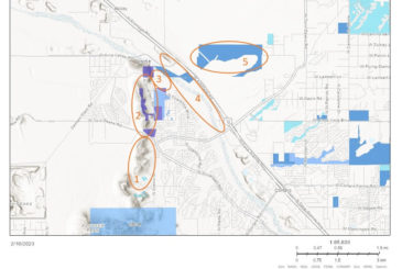
Pima County pursues new protected open spaces
Late last year, Pima County announced a slate of new protected open space acquisitions they are pursuing with the $2 million allocated for the acquisition of conservation land in the […]

2022 Wildlife Camera Project Recap
2022 was another successful year for our Wildlife Camera Monitoring Program, and also our 10th anniversary of this community science-based project! Big thanks to ALL the volunteers that have been […]

The latest on I-11: Lawsuit sees its first day in court
On Wednesday, January 25, 2023, U.S. District Judge John C. Hinderaker heard arguments on the federal government’s motion to dismiss a portion of our challenge to Interstate 11 filed in […]
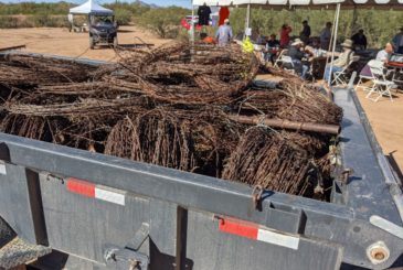
Desert Fence Busters tackle the Big Wash in Oro Valley
In mid-November 2022, the Desert Fence Busters tackled a section of the Big Wash in Oro Valley. Over the course of a beautiful Saturday morning, 35 people removed 1.5 miles […]

Remembering and Celebrating Josh
Our community suffered a tragic loss when our first Desert Wildlife Intern and long-time volunteer Josh Skattum died tragically on October 22, 2022 after being involved in a serious car […]
The latest on Interstate 11 and our lawsuit
The Coalition has been involved in commenting on the proposal for a new southern Arizona federal highway, Interstate 11, for a decade. We first commented on the Corridor Justification Study […]
Pima County’s 2021 MSCP Annual Report
Pima County recently released their 2021 MSCP Annual Report. The MSCP – or Multi-Species Habitat Conservation Plan – is an integral part of the larger Sonoran Desert Conservation Plan. According […]
Welcome to our first Desert Wildlife Intern!
We are excited to announce and welcome our first Desert Wildlife Intern! Josh Skattum (he/him/his) will be joining our staff on a part-time basis from August-December and we are so […]

Pima County’s Open Space Conservation Acquisitions: An Overview
Pima County has invested heavily in acquiring conservation properties, especially in fulfilling the goals of the Sonoran Desert Conservation Plan. The County recently released a new report about all their […]